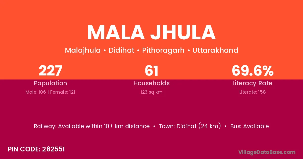
Mala Jhula village is located in the Didihat Tehsil of the Pithoragarh district in Uttarakhand .
Block / Tehsil → Didihat
District → Pithoragarh
State → Uttarakhand
According to Census 2011 information, the village code of Mala Jhula village is 262551.
Mala Jhula village has a total population of 227 people, of which 106 are males and 121 are females.
The literacy rate of Mala Jhula village is 69.60%. Male literacy stands at 83.96% and female literacy at 57.02%.
There are approximately 61 households in Mala Jhula village.
Didihat (24 km) is the nearest town to Mala Jhula village for major economic activities and is located approximately 24 km away.
The population of Mala Jhula village is distributed between literate and illiterate residents as follows:
| Particulars | Male | Female | Total |
|---|---|---|---|
| Literate | 89 | 69 | 158 |
| Illiterate | 17 | 52 | 69 |
| Total | 106 | 121 | 227 |
Source: Census 2011
| Village | District |
|---|---|
| Bagjiwala | Champawat |
| Bagjiwala | Pithoragarh |
| Bagjiwala | Rudraprayag |
| Basaura | Aurangabad |
| Basaura | Aurangabad |
| Basaura | Rohtas |
| Basaura | Palamu |
| Basaura | Panna |
| Basaura | Panna |
| Basaura | Satna |
| Basaura | Kanpur Nagar |
| Basaura | Pithoragarh |
| Dungar Gara | Pithoragarh |
| Ghimali | Pithoragarh |
| Gwinauli | Pithoragarh |
| Gwir Ghattigar | Pithoragarh |
| Naulia Gaon | Pithoragarh |
| Rani Khet | Pithoragarh |
| Turgoli | Pithoragarh |
No reviews yet. Be the first to review this village!
Available within 10+ km distance
Available within <5 km distance
Available within <5 km distance