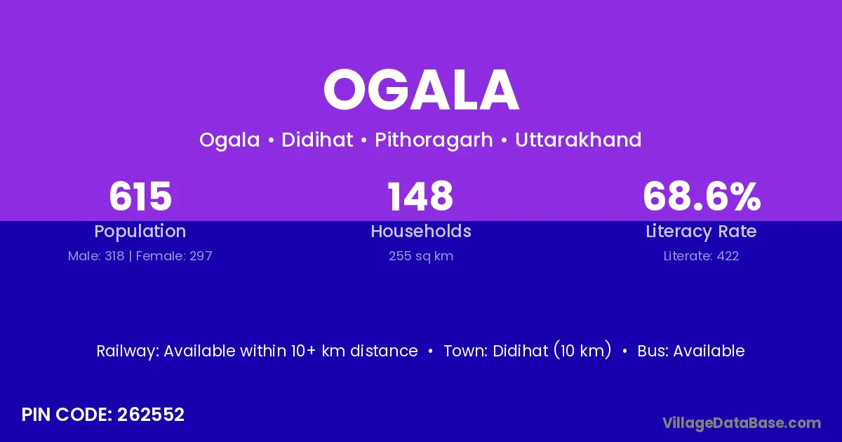
Ogala village is located in the Didihat Tehsil of the Pithoragarh district in Uttarakhand .
Block / Tehsil → Didihat
District → Pithoragarh
State → Uttarakhand
According to Census 2011 information, the village code of Ogala village is 262552.
Ogala village has a total population of 615 people, of which 318 are males and 297 are females.
The literacy rate of Ogala village is 68.62%. Male literacy stands at 78.30% and female literacy at 58.25%.
There are approximately 148 households in Ogala village.
Didihat (10 km) is the nearest town to Ogala village for major economic activities and is located approximately 10 km away.
The population of Ogala village is distributed between literate and illiterate residents as follows:
| Particulars | Male | Female | Total |
|---|---|---|---|
| Literate | 249 | 173 | 422 |
| Illiterate | 69 | 124 | 193 |
| Total | 318 | 297 | 615 |
Source: Census 2011
| Village | District |
|---|---|
| Atkwali | Pithoragarh |
| Baltir | Pithoragarh |
| Bhul Gaon | Bageshwar |
| Bhul Gaon | Pithoragarh |
| Kanda Jhusiya | Pithoragarh |
| Kanda Mansingh | Pithoragarh |
| Karauli | Dungarpur |
| Karauli | Auraiya |
| Karauli | Bijnor |
| Karauli | Sonbhadra |
| Karauli | Unnao |
| Karauli | Champawat |
| Karauli | Pithoragarh |
| Kasindev | Pithoragarh |
| Ladhara | Pithoragarh |
| Sata | Rayagada |
| Sata | Barmer |
| Sata | Jaisalmer |
| Sata | Sultanpur |
| Sata | Pithoragarh |
| Talli Mirthi | Pithoragarh |
| Tunera | Pithoragarh |
| Tunera | Pithoragarh |
No reviews yet. Be the first to review this village!
Available within 10+ km distance
Available within <5 km distance
Available within <5 km distance