District → Champawat
State → Uttarakhand
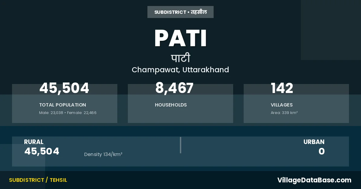
Pati is a town and Tehsil in the Champawat district of the Uttarakhand. In India, a Tehsil is a subdivision of a district responsible for the administration and revenue collection of a specific area within the district. Tehsils play a crucial role in the local governance structure, contributing significantly to the development and administration of their communities.
According to the 2011 census The total area of Pati Tehsil is 339 km², with a population of 45504 people. The population density is 134 inhabitants per square kilometre, and there are approximately 8467 houses in the sub district.
Pati Tehsil comprises about 142 villages. Below is a list of these villages along with information about their respective gram panchayats and the nearest town:
| # | Village Name | Gram Panchayat | Nearest Town |
|---|---|---|---|
| 1 | Amauli | Amoli | Lohaghat (44 km) |
| 2 | Anarpa | Anarpa | Lohaghat (60 km) |
| 3 | Bairakh | Bhainskar | Lohaghat (45 km) |
| 4 | Balatari | Baltari | Lohaghat (42 km) |
| 5 | Baligaon | Patan Gaon | Lohaghat (40 km) |
| 6 | Baman Chapar | Anarpa | Lohaghat (62 km) |
| 7 | Banauli | Banauly | Lohaghat (59 km) |
| 8 | Banoli Lagga Dungra | Banauly | Lohaghat (62 km) |
| 9 | Barait | Railmel | Lohaghat (34 km) |
| 10 | Barmtora | Gahtoda | Lohaghat (31 km) |
| 11 | Basanjoga | Rikholi | Lohaghat (65 km) |
| 12 | Basaut | Kamlekh | Lohaghat (30 km) |
| 13 | Baswari | Bans Banswali | Lohaghat (36 km) |
| 14 | Batuliya | Rikholi | Lohaghat (64 km) |
| 15 | Bhaisarkh | Bhainskar | Lohaghat (45 km) |
| 16 | Bham Lagga Mulakot | Mula Kot | Lohaghat (43 km) |
| 17 | Bhingrad Range | Lohaghat (45 km) | |
| 18 | Bhingrara | Bhingrada | Lohaghat (43 km) |
| 19 | Bhonkara | Manglekh | Lohaghat (70 km) |
| 20 | Bhumwari | Bhumwari | Lohaghat (45 km) |
| 21 | Bigrakot | Bigrakot | Lohaghat (39 km) |
| 22 | Binwal Gaon | Binwal Gaon | Lohaghat (68 km) |
| 23 | Biroli | Lohaghat (55 km) | |
| 24 | Bora Chapar | Kimad | Lohaghat (58 km) |
| 25 | Bunga Birora | Holi Piplati | Lohaghat (30 km) |
| 26 | Burush Khola | Nilauty | Lohaghat (32 km) |
| 27 | Chalthiya | Chalthiya | Lohaghat (47 km) |
| 28 | Chamtola | Lohaghat (54 km) | |
| 29 | Chaura Guth | Chaura Gunth | Lohaghat (70 km) |
| 30 | Chaura Maheta | Chaura Maheta | Lohaghat (65 km) |
| 31 | Chaura Pita | Chaura Pita | Lohaghat (75 km) |
| 32 | Chaura Sown | Chora Saun | Lohaghat (46 km) |
| 33 | Chaurakot | Chora Kot | Lohaghat (37 km) |
| 34 | Chhoragaon | Karauly | Lohaghat (43 km) |
| 35 | Chilniya | Chilniya | Lohaghat (56 km) |
| 36 | Dabri | Parewa | Lohaghat (69 km) |
| 37 | Dantola | Gagar | Lohaghat (59 km) |
| 38 | Dashiya | Dasiyachami | Lohaghat (38 km) |
| 39 | Dechmar | Devi Dhura | Lohaghat (45 km) |
| 40 | Devidhura Range | Lohaghat (28 km) | |
| 41 | Dharson | Dharsaun | Lohaghat (68 km) |
| 42 | Dhaunkim Sawar | Mantandy | Lohaghat (59 km) |
| 43 | Dhraug | Dharaunch | Lohaghat (40 km) |
| 44 | Dubar Kamlaikh | Nilauty | Lohaghat (31 km) |
| 45 | Dungra Kot | Dungrakot | Lohaghat (44 km) |
| 46 | Ejatta Hungra | Ittaza Dungra | Lohaghat (48 km) |
| 47 | Fularakot | Peepal Teeng | Lohaghat (58 km) |
| 48 | Gadura | Gadyura | Lohaghat (46 km) |
| 49 | Gagar | Gagar | Lohaghat (53 km) |
| 50 | Gagrarh | Gagar | Lohaghat (55 km) |
| 51 | Garsari | Garsari | Lohaghat (35 km) |
| 52 | Gawai | Gawayie | Lohaghat (62 km) |
| 53 | Geeju Baswan | Bans Banswali | Lohaghat (40 km) |
| 54 | Ghahtora | Gahtoda | Lohaghat (35 km) |
| 55 | Ghigharukot | Sango | Lohaghat (40 km) |
| 56 | Golana Seri | Patan Gaon | Lohaghat (40 km) |
| 57 | Goldanda | Gol Danda | Lohaghat (70 km) |
| 58 | Goom | Gum | Lohaghat (35 km) |
| 59 | Haldua Khark | Gahtoda | Lohaghat (30 km) |
| 60 | Holi Piplati | Holi Piplati | Lohaghat (29 km) |
| 61 | Jadia Kamad | Railmel | Lohaghat (40 km) |
| 62 | Jakhola | Kotna | Lohaghat (43 km) |
| 63 | Jamantak | Sango | Lohaghat (38 km) |
| 64 | Jarauli | Jhudailee | Lohaghat (35 km) |
| 65 | Jawlari | Jauladi | Lohaghat (33 km) |
| 66 | Jhalpura | Bhumwari | Lohaghat (44 km) |
| 67 | Jhar Sirtoli | Gahtoda | Lohaghat (32 km) |
| 68 | Jhudaili | Jhudailee | Lohaghat (37 km) |
| 69 | Kajeena | Kajeena | Lohaghat (51 km) |
| 70 | Kamlakh | Kamlekh | Lohaghat (26 km) |
| 71 | Kandey | Mula Kot | Lohaghat (47 km) |
| 72 | Kanikot | Kani Kot | Lohaghat (42 km) |
| 73 | Kanikot Lagga Chora Guth | Chaura Gunth | Lohaghat (70 km) |
| 74 | Kanwar | Kanwar | Lohaghat (47 km) |
| 75 | Kaphalti | Sango | Lohaghat (41 km) |
| 76 | Karauli | Karauly | Lohaghat (45 km) |
| 77 | Karki Chhana | Mantandy | Lohaghat (59 km) |
| 78 | Karwalgaon | Mara Gaon | Lohaghat (22 km) |
| 79 | Kharhi | Kharahi | Lohaghat (52 km) |
| 80 | Kharni Guth | Timilagunth | Lohaghat (58 km) |
| 81 | Kimar | Kimad | Lohaghat (55 km) |
| 82 | Kimwari | Jhudailee | Lohaghat (49 km) |
| 83 | Koond | Kund | Lohaghat (40 km) |
| 84 | Kota | Railmel | Lohaghat (35 km) |
| 85 | Kotna | Kotna | Lohaghat (43 km) |
| 86 | Kulyal Gaon | Kulyalgaon | Lohaghat (65 km) |
| 87 | Kumaiya Kuda | Timilagunth | Lohaghat (57 km) |
| 88 | Kwarala | Bhingrada | Lohaghat (44 km) |
| 89 | Lara | Railmel | Lohaghat (37 km) |
| 90 | Machhiyar | Machhiyad | Lohaghat (68 km) |
| 91 | Madyoli | Chalthiya | Lohaghat (47 km) |
| 92 | Mailta | Gahtoda | Lohaghat (25 km) |
| 93 | Mairoli | Railmel | Lohaghat (49 km) |
| 94 | Mangal Lekh | Manglekh | Lohaghat (65 km) |
| 95 | Mantande | Mantandy | Lohaghat (60 km) |
| 96 | Maragaon | Mara Gaon | Lohaghat (23 km) |
| 97 | Mathaila Chhana | Takna Gurau | Lohaghat (64 km) |
| 98 | Maulanajakh | Molna Jakh | Lohaghat (56 km) |
| 99 | Maun | Kund | Lohaghat (44 km) |
| 100 | Maun Kanda | Maun Kanda | Lohaghat (40 km) |
| 101 | Mulakot | Mula Kot | Lohaghat (44 km) |
| 102 | Naini | Jhudailee | Lohaghat (35 km) |
| 103 | Nauliya Gaon | Gol Danda | Lohaghat (77 km) |
| 104 | Nayalkot | Punauly | Lohaghat (52 km) |
| 105 | Niloti | Nilauty | Lohaghat (30 km) |
| 106 | Pakhauti | Pakhauti | Lohaghat (47 km) |
| 107 | Pamtola | Jhudailee | Lohaghat (33 km) |
| 108 | Parewa | Parewa | Lohaghat (66 km) |
| 109 | Parsh | Rikholi | Lohaghat (63 km) |
| 110 | Patangaon | Patan Gaon | Lohaghat (40 km) |
| 111 | Patharkot | Gahtoda | Lohaghat (27 km) |
| 112 | Pati | Pati | Lohaghat (30 km) |
| 113 | Pipal Dhing | Peepal Teeng | Lohaghat (60 km) |
| 114 | Pokhari | Barsee | Lohaghat (70 km) |
| 115 | Punoli | Punauly | Lohaghat (52 km) |
| 116 | Ramak | Ramak | Lohaghat (70 km) |
| 117 | Raulgaon | Takna Gurau | Lohaghat (65 km) |
| 118 | Reetha | Bigrakot | Lohaghat (47 km) |
| 119 | Rikholi | Rikholi | Lohaghat (59 km) |
| 120 | Rolmail | Railmel | Lohaghat (47 km) |
| 121 | Roodauli | Jhudailee | Lohaghat (37 km) |
| 122 | Sakdena | Sakdena | Lohaghat (37 km) |
| 123 | Sal | Saal | Lohaghat (76 km) |
| 124 | Sango | Sango | Lohaghat (40 km) |
| 125 | Sibyoli | Sibyoly | Lohaghat (69 km) |
| 126 | Silyori | Silyuri Gunth | Lohaghat (70 km) |
| 127 | Simalkhet | Chilniya | Lohaghat (57 km) |
| 128 | Sirkot | Bigrakot | Lohaghat (44 km) |
| 129 | Sirna | Barsee | Lohaghat (62 km) |
| 130 | Sundungra | Sundungara | Lohaghat (37 km) |
| 131 | Takbalwari | Takbalwari | Lohaghat (34 km) |
| 132 | Takna Gurau | Takna Gurau | Lohaghat (65 km) |
| 133 | Tanda Malla | Tanda Malla | Lohaghat (80 km) |
| 134 | Tanda Talla | Tanda Malla | Lohaghat (80 km) |
| 135 | Tapnipal | Tapni Pal | Lohaghat (20 km) |
| 136 | Thapla Gunth | Chaura Gunth | Lohaghat (80 km) |
| 137 | Thuwa Mauni | Thuwa Mauni | Lohaghat (38 km) |
| 138 | Timla Guth | Timilagunth | Lohaghat (57 km) |
| 139 | Tolarankuri | Gol Danda | Lohaghat (70 km) |
| 140 | Toli Katheri | Chaura Gunth | Lohaghat (70 km) |
| 141 | Valik | Balik | Lohaghat (55 km) |
| 142 | Varshi | Barsee | Lohaghat (60 km) |
The population is distributed between urban and rural areas as follows:
| Particulars | Rural | Urban | Total |
|---|---|---|---|
| Total Population | 45504 | 0 | 45504 |
| Male Population | 23038 | 0 | 23038 |
| Female Population | 22466 | 0 | 22466 | Population Density | 134 / km² | 134 / km² |
The distribution of households in the Pati is:
| Rural Households | Urban Households | Total Households |
|---|---|---|
| 8467 | 0 | 8467 |
Q: What is Pati?
A: Pati is a town and in the Champawat district of the Uttarakhand.
Q: What is the total area of Pati Tehsil?
A: The total area of Pati Tehsil is 339 km².
Q: What is the population of Pati Tehsil according to the 2011 census?
A: According to the 2011 census, the population of Pati Tehsil is 45504.
Q: What is the population density of Pati Tehsil?
A: The population density of Pati Tehsil is 134 inhabitants per square kilometre.
Q: How many houses are there in Pati Tehsil?
A: There are approximately 8467 houses in Pati Tehsil.
Q: How many villages are there in Pati Tehsil?
A: There are about 142 villages in Pati Tehsil.
Q: Which is the largest village by population in Pati Tehsil?
A: The largest village by population in Pati Tehsil is Pati, with 1559 people.
Q: Which is the smallest village by population in Pati Tehsil?
A: The smallest village by population in Pati Tehsil is Devidhura Range, with 0 people.
Q: Which is the largest village by area in Pati Tehsil?
A: The largest village by area in Pati Tehsil is Ramak, with 1015 km².
Q: Which is the smallest village by area in Pati Tehsil?
A: The smallest village by area in Pati Tehsil is Bhingrad Range, with 1 km².
Q: What is the population distribution between urban and rural areas in Pati Tehsil?
A: The population distribution in Pati Tehsil is entirely rural, with a total rural population of 45504.
Q: What is the male population of Pati Tehsil?
A: The male population of Pati Tehsil is 23038.
Q: What is the female population of Pati Tehsil?
A: The female population of Pati Tehsil is 22466.
Q: How is the household distribution in Pati Tehsil?
A: The household distribution in Pati Tehsil is entirely rural, with a total of 8467 households.
Q: How many villages in Pati Tehsil have a population of less than 100?
A: There are 36 villages in Pati Tehsil with a population of less than 100.
Q: How many villages in Pati Tehsil have a population between 100 and 499?
A: There are 75 villages in Pati Tehsil with a population between 100 and 499.
Q: How many villages in Pati Tehsil have a population between 500 and 999?
A: There are 25 villages in Pati Tehsil with a population between 500 and 999.
Q: How many villages in Pati Tehsil have a population between 1000 and 1999?
A: There are 6 villages in Pati Tehsil with a population between 1000 and 1999.
| Total Population | Villages in Sub District Of Pati |
|---|---|
| Less than 100 | 36 |
| 100-499 | 75 |
| 500-999 | 25 |
| 1000-1999 | 6 |