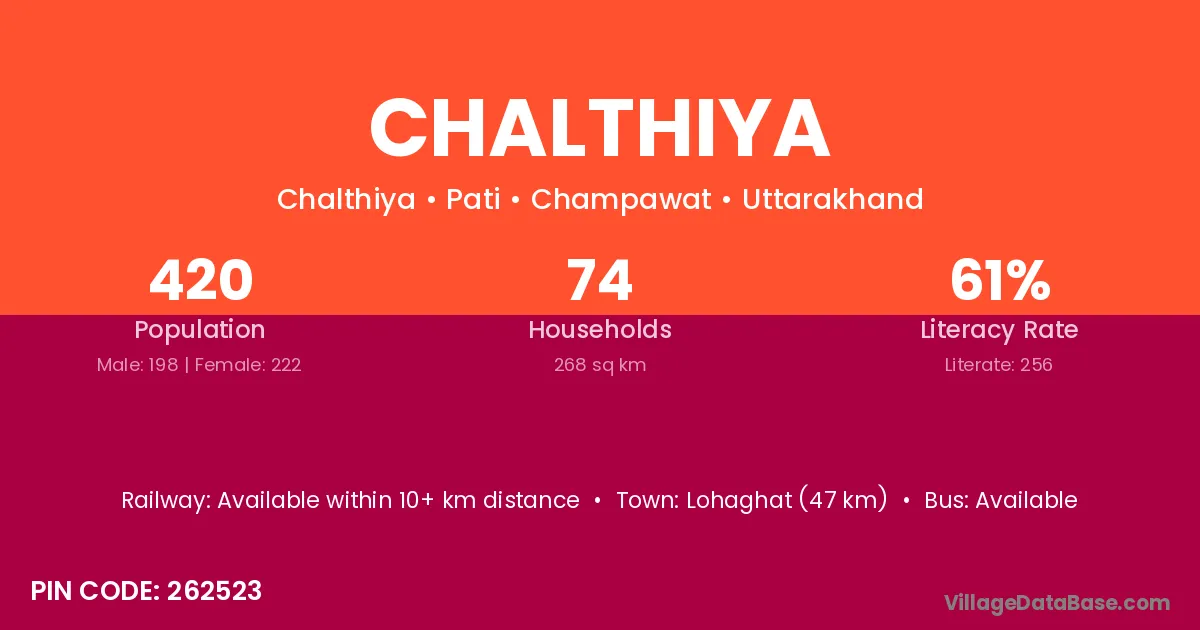
Chalthiya village is located in the Pati Tehsil of the Champawat district in Uttarakhand .
Block / Tehsil → Pati
District → Champawat
State → Uttarakhand
According to Census 2011 information, the village code of Chalthiya village is 262523.
Chalthiya village has a total population of 420 people, of which 198 are males and 222 are females.
The literacy rate of Chalthiya village is 60.95%. Male literacy stands at 74.75% and female literacy at 48.65%.
There are approximately 74 households in Chalthiya village.
Lohaghat (47 km) is the nearest town to Chalthiya village for major economic activities and is located approximately 47 km away.
The population of Chalthiya village is distributed between literate and illiterate residents as follows:
| Particulars | Male | Female | Total |
|---|---|---|---|
| Literate | 148 | 108 | 256 |
| Illiterate | 50 | 114 | 164 |
| Total | 198 | 222 | 420 |
Source: Census 2011
| Village | District |
|---|---|
| Bhingrara | Champawat |
| Bhonkara | Champawat |
| Chaura Maheta | Champawat |
| Chaura Pita | Champawat |
| Gadura | Rohtas |
| Gadura | Champawat |
| Gadura | Nainital |
| Kulyal Gaon | Champawat |
| Machhiyar | Champawat |
| Madyoli | Champawat |
| Parewa | Gaya |
| Parewa | Purba Champaran |
| Parewa | Saharsa |
| Parewa | Surguja |
| Parewa | Latehar |
| Parewa | Guna |
| Parewa | Jhabua |
| Parewa | Raisen |
| Parewa | Satna |
| Parewa | Ballia |
| Parewa | Ballia |
| Parewa | Basti |
| Parewa | Chandauli |
| Parewa | Ghazipur |
| Parewa | Kheri |
| Parewa | Rampur |
| Parewa | Sitapur |
| Parewa | Sitapur |
| Parewa | Champawat |
| Parewa | Nainital |
| Sal | Chamba |
| Sal | Shimla |
| Sal | Pune |
| Sal | Champawat |
| Tanda Talla | Champawat |
No reviews yet. Be the first to review this village!
Available within 10+ km distance
Available within <5 km distance
Available within <5 km distance