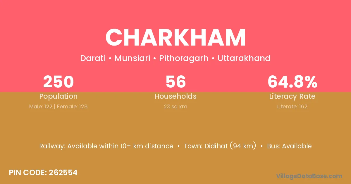
Charkham village is located in the Munsiari Tehsil of the Pithoragarh district in Uttarakhand .
Block / Tehsil → Munsiari
District → Pithoragarh
State → Uttarakhand
According to Census 2011 information, the village code of Charkham village is 262554.
Charkham village has a total population of 250 people, of which 122 are males and 128 are females.
The literacy rate of Charkham village is 64.80%. Male literacy stands at 70.49% and female literacy at 59.38%.
There are approximately 56 households in Charkham village.
Didihat (94 km) is the nearest town to Charkham village for major economic activities and is located approximately 94 km away.
The population of Charkham village is distributed between literate and illiterate residents as follows:
| Particulars | Male | Female | Total |
|---|---|---|---|
| Literate | 86 | 76 | 162 |
| Illiterate | 36 | 52 | 88 |
| Total | 122 | 128 | 250 |
Source: Census 2011
| Village | District |
|---|---|
| Ghor Patta Talla | Pithoragarh |
| Kaiti | Pithoragarh |
| Kaiti | Barddhaman |
| Kirkhet | Pithoragarh |
| Mana Chulankar | Pithoragarh |
| Matena | Vidisha |
| Matena | Bageshwar |
| Matena | Pithoragarh |
| Matyali | Pithoragarh |
| Papri | Mewat |
| Papri | Palwal |
| Papri | Sahibzada Ajit Singh Nagar |
| Papri | Bundi |
| Papri | Jaipur |
| Papri | Saharanpur |
| Papri | Nainital |
| Papri | Pithoragarh |
| Sebila | Pithoragarh |
| Sela Chital | Pithoragarh |
| Sella Malla | Pithoragarh |
| Sera Surai Dhar | Pithoragarh |
No reviews yet. Be the first to review this village!
Available within 10+ km distance
Available within 5 - 10 km distance
Available within 5 - 10 km distance