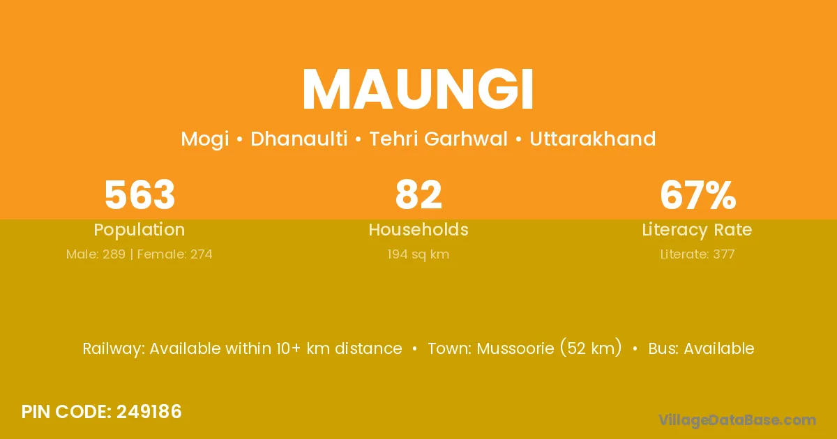
Maungi village is located in the Dhanaulti Tehsil of the Tehri Garhwal district in Uttarakhand .
Block / Tehsil → Dhanaulti
District → Tehri Garhwal
State → Uttarakhand
According to Census 2011 information, the village code of Maungi village is 249186.
Maungi village has a total population of 563 people, of which 289 are males and 274 are females.
The literacy rate of Maungi village is 66.96%. Male literacy stands at 77.16% and female literacy at 56.20%.
There are approximately 82 households in Maungi village.
Mussoorie (52 km) is the nearest town to Maungi village for major economic activities and is located approximately 52 km away.
The population of Maungi village is distributed between literate and illiterate residents as follows:
| Particulars | Male | Female | Total |
|---|---|---|---|
| Literate | 223 | 154 | 377 |
| Illiterate | 66 | 120 | 186 |
| Total | 289 | 274 | 563 |
Source: Census 2011
| Village | District |
|---|---|
| Chandwan Gaon | Tehri Garhwal |
| Ghera | Kangra |
| Ghera | Mandi |
| Ghera | Bharatpur |
| Ghera | Tehri Garhwal |
| Ghera | Uttar Dinajpur |
| Ghera | Uttar Dinajpur |
| Ghorakhuri | Tehri Garhwal |
| Magdiya Chak Koti Madhe | Tehri Garhwal |
| Mair | Hamirpur |
| Mair | Shahdol |
| Mair | Tehri Garhwal |
| Mason | Ghazipur |
| Mason | Ghazipur |
| Mason | Chamoli |
| Mason | Tehri Garhwal |
| Masras | Tehri Garhwal |
| Sanab Malla | Tehri Garhwal |
| Sauntiyal Gaon | Tehri Garhwal |
| Tangri | Solan |
| Tangri | West Khasi Hills |
| Tangri | Tehri Garhwal |
| Thureti | Tehri Garhwal |
No reviews yet. Be the first to review this village!
Available within 10+ km distance
Available within village
Available within village