Welcome Back

Forgot password?
Don't have an account?
🏘️ Menu
Birbhum District 0.0 / 5 (0)

Magura Village Detailed Information

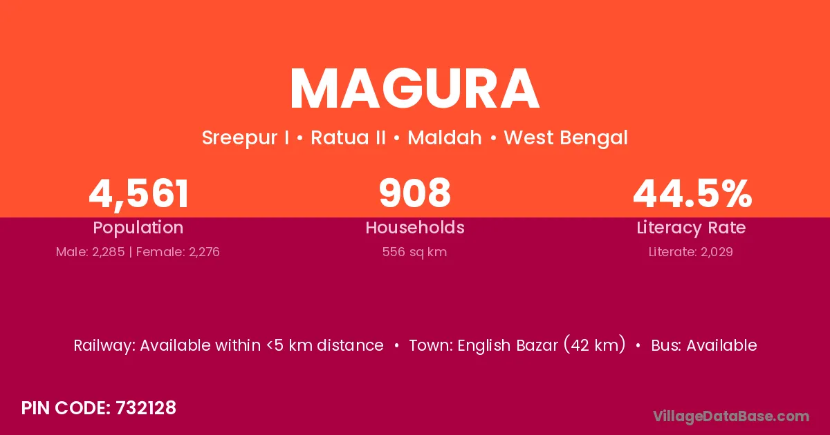
Magura village is located in the Sainthia Subdivision of the Birbhum district in West Bengal .

About Magura Village

Block / Subdivision → Sainthia

District → Birbhum

State → West Bengal

Sainthia is the nearest town to Magura village for major economic activities

Population of Magura Village

The population of Magura village is distributed between literate and illiterate residents as follows:

Population distribution of Magura village by literacy and gender
Particulars Male Female Total
Literate 0 0 0
Illiterate 0 0 0
Total 0 0 0

Source: Census 2011

Nearby Villages

List of nearby villages around Magura village
Village District
Abhirampur Bankura
Abhirampur Bankura
Abhirampur Barddhaman
Abhirampur Birbhum
Abhirampur Dakshin Dinajpur
Abhirampur Haora
Abhirampur Haora
Abhirampur Hugli
Abhirampur North Twenty Four Parganas
Abhirampur Paschim Medinipur
Abhirampur South Twenty Four Parganas
Abhirampur North Twenty Four Parganas
Abhirampur Paschim Medinipur
Abhirampur South Twenty Four Parganas
Bagrakanda Birbhum
Bengra Pashchim Champaran
Bengra Birbhum
Bhalian Rupnagar
Bhalian Birbhum
Bhalian Birbhum
Chhautara Birbhum
Derpur Birbhum
Hatara Kangra
Hatara Birbhum
Jollo Birbhum
Kumratari Birbhum
Mahishdahari Birbhum
Matpalsha Birbhum

Frequently Asked Questions

Magura village is located in the Sainthia Subdivision of the Birbhum district in West Bengal.
The total population is 0 people.
0 males and 0 females.
There are approximately 0 houses in Magura village.
Sainthia is the nearest town, located approximately km away.

Reviews and Ratings

0.0 / 5 (0 reviews)

Reviews

No reviews yet. Be the first to review this village!

Magura Village Statistics

Population
0
Area
48 km²
Nearest Town :
Sainthia

Quick Information

State / UT : West Bengal
Total Area : 48 km²
Gram Panchayat : Mathpalsa
Nearest Town : Sainthia

Connectivity of Magura

Need Help?

Contact local tourism office for assistance