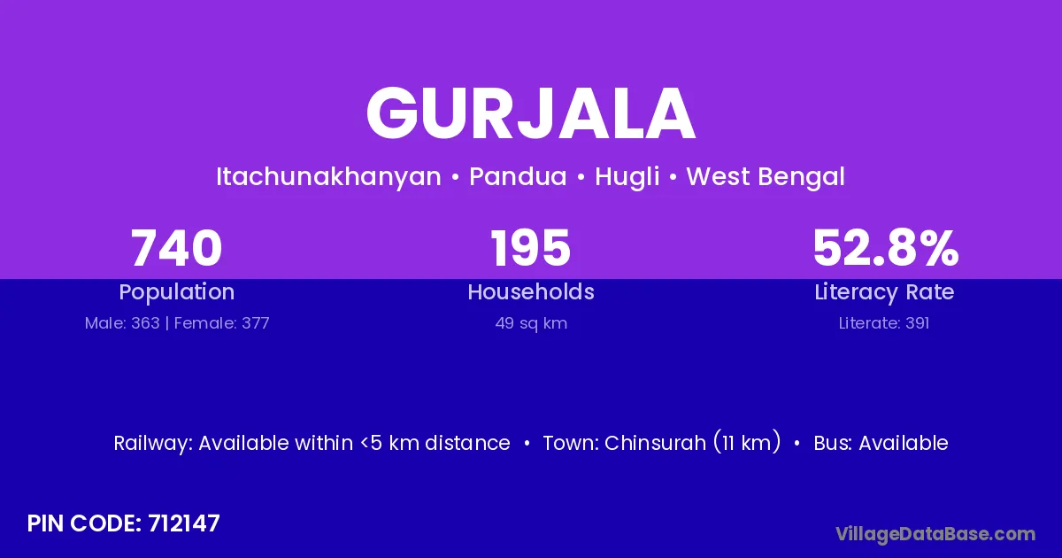
Gurjala village is located in the Pandua Subdivision of the Hugli district in West Bengal .
Block / Subdivision → Pandua
District → Hugli
State → West Bengal
According to Census 2011 information, the village code of Gurjala village is 712147.
Gurjala village has a total population of 740 people, of which 363 are males and 377 are females.
The literacy rate of Gurjala village is 52.84%. Male literacy stands at 58.95% and female literacy at 46.95%.
There are approximately 195 households in Gurjala village.
Chinsurah (11 km) is the nearest town to Gurjala village for major economic activities and is located approximately 11 km away.
The population of Gurjala village is distributed between literate and illiterate residents as follows:
| Particulars | Male | Female | Total |
|---|---|---|---|
| Literate | 214 | 177 | 391 |
| Illiterate | 149 | 200 | 349 |
| Total | 363 | 377 | 740 |
Source: Census 2011
| Village | District |
|---|---|
| Barasarasa | Hugli |
| Benedanga | Hugli |
| Berui | Saran |
| Berui | Allahabad |
| Berui | Kaushambi |
| Berui | Hugli |
| Itachuna | Hugli |
| Khanyan | Hugli |
| Makhaldi | Hugli |
| Mandaran | Hugli |
| Mandaran | Hugli |
| Mulati | Hugli |
| Niala | Khordha |
| Niala | Hugli |
| Sankpur | Hugli |
| Shyam Sundarpur | Azamgarh |
| Shyam Sundarpur | Bankura |
| Shyam Sundarpur | Hugli |
| Shyam Sundarpur | Paschim Medinipur |
| Shyam Sundarpur | Paschim Medinipur |
No reviews yet. Be the first to review this village!
Available within <5 km distance
Available within <5 km distance
Available within <5 km distance