Welcome Back

Forgot password?
Don't have an account?
🏘️ Menu
Puruliya District 0.0 / 5 (0)

Postabera Village Detailed Information

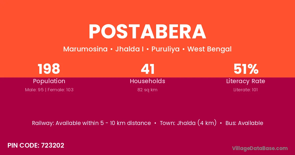
Postabera village is located in the Jhalda I Subdivision of the Puruliya district in West Bengal .

About Postabera Village

Block / Subdivision → Jhalda I

District → Puruliya

State → West Bengal

According to Census 2011 information, the village code of Postabera village is 723202.

Postabera village has a total population of 198 people, of which 95 are males and 103 are females.

The literacy rate of Postabera village is 51.01%. Male literacy stands at 60.00% and female literacy at 42.72%.

There are approximately 41 households in Postabera village.

Jhalda (4 km) is the nearest town to Postabera village for major economic activities and is located approximately 4 km away.

Population of Postabera Village

The population of Postabera village is distributed between literate and illiterate residents as follows:

Population distribution of Postabera village by literacy and gender
Particulars Male Female Total
Literate 57 44 101
Illiterate 38 59 97
Total 95 103 198

Source: Census 2011

Nearby Villages

List of nearby villages around Postabera village
Village District
Bansa Durg
Bansa Surguja
Bansa Karnal
Bansa Bokaro
Bansa Saraikela Kharsawan
Bansa Rewa
Bansa Sagar
Bansa Shahdol
Bansa Umaria
Bansa Umaria
Bansa Jagatsinghapur
Bansa Chittaurgarh
Bansa Nagaur
Bansa Rajsamand
Bansa Bara Banki
Bansa Hardoi
Bansa Barddhaman
Bansa Puruliya
Bansa Puruliya
Bansa Puruliya
Bansa Puruliya
Chamardag Puruliya
Chamardag Puruliya
Dumardi Puruliya
Dumardi Puruliya
Dumardi Puruliya
Dumardi Puruliya
Guridi Puruliya
Guridi Puruliya
Guridi Puruliya
Guridi Puruliya
Joratanr Puruliya
Joratanr Puruliya
Kansra Patna
Kansra Bilaspur
Kansra Puruliya
Kansra Puruliya
Kerawari Puruliya
Kerawari Puruliya
Khatjuri Puruliya
Khatjuri Puruliya
Merend Puruliya
Merend Puruliya
Paparu Puruliya
Paparu Puruliya
Uhupiri Puruliya
Uhupiri Puruliya

Frequently Asked Questions

Postabera village is located in the Jhalda I Subdivision of the Puruliya district in West Bengal.
The total population is 198 people.
95 males and 103 females.
The literacy rate is 51.01%.
Male literacy rate is 60.00%, and female literacy rate is 42.72%.
There are approximately 41 houses in Postabera village.
Jhalda (4 km) is the nearest town, located approximately 4 km away.

Reviews and Ratings

0.0 / 5 (0 reviews)

Reviews

No reviews yet. Be the first to review this village!

Postabera Village Statistics

Population
198
Area
82 km²
Households
41
Nearest Town :
Jhalda (4 km)

Quick Information

State / UT : West Bengal
Pincode : 723202
Total Area : 82 km²
Population : 198
Households : 41
Gram Panchayat : Marumosina
Nearest Town : Jhalda (4 km)

Connectivity of Postabera

🚂 Railway Station

Available within 5 - 10 km distance

🚌 Public Bus Service

Available within <5 km distance

🚌 Private Bus Service

Available within village

Need Help?

Contact local tourism office for assistance