Sangram: A Town and Circle in Kurung Kumey district
District → Kurung Kumey
State → Arunachal Pradesh
Sangram is a town and Circle in the Kurung Kumey district of the Arunachal Pradesh. In India, a Circle is a subdivision of a district responsible for the administration and revenue collection of a specific area within the district. Circles play a crucial role in the local governance structure, contributing significantly to the development and administration of their communities.
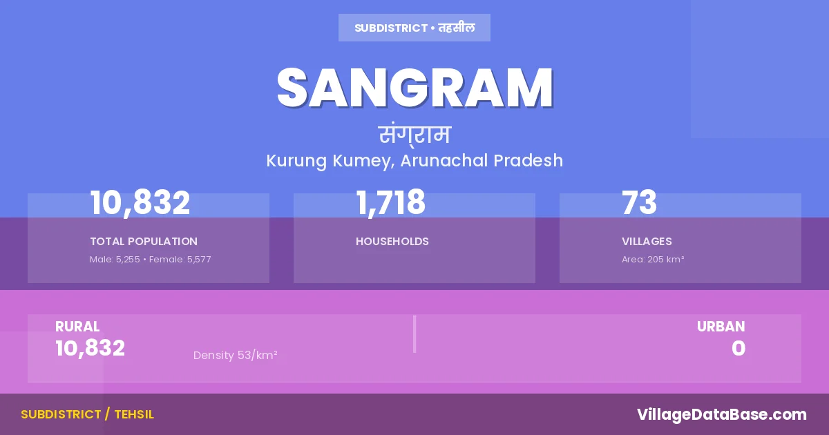
According to the 2011 census The total area of Sangram Circle is 205 km², with a population of 10832 people. The population density is 53 inhabitants per square kilometre, and there are approximately 1718 houses in the sub district.
Sangram Circle comprises about 73 villages. Below is a list of these villages along with information about their respective gram panchayats and the nearest town:
| # | Village Name | Gram Panchayat | Nearest Town |
|---|---|---|---|
| 1 | 6 Mile Camp | Sangram (6 km) | |
| 2 | Begang | Sangram (23 km) | |
| 3 | Byasi | Sangram (13 km) | |
| 4 | Cheki | Sangram (26 km) | |
| 5 | Chingliang | Sangram (12 km) | |
| 6 | Dangu | Sangram (14 km) | |
| 7 | Dara | Sangram | |
| 8 | Delung | Sangram (23 km) | |
| 9 | Demepup | Sangram (25 km) | |
| 10 | Dengba | Sangram (18 km) | |
| 11 | Dera | Sangram (24 km) | |
| 12 | Dokum Coloney | Sangram (1 km) | |
| 13 | Gangte | Sangram (3 km) | |
| 14 | Hacho | Sangram | |
| 15 | Hagang | Sangram (8 km) | |
| 16 | Haggar | Sangram (24 km) | |
| 17 | Hatam | Sangram (16 km) | |
| 18 | Hiba | Hiba I | Sangram (20 km) |
| 19 | Hocho | Sangram (31 km) | |
| 20 | Hote | Sangram (4 km) | |
| 21 | Kaglang | Sangram (27 km) | |
| 22 | Kambang | Sangram (12 km) | |
| 23 | Kamcho Koyor | Sangram | |
| 24 | Kamha Hapa | Sangram (12 km) | |
| 25 | Kampong | Sangram (3 km) | |
| 26 | Kamrung | Sangram (13 km) | |
| 27 | Kayung | Sangram (9 km) | |
| 28 | Kerium Hapa | Sangram (18 km) | |
| 29 | Laba | Sangram (32 km) | |
| 30 | Leel | Sangram (15 km) | |
| 31 | Leel Camp | Sangram (15 km) | |
| 32 | Lengrik | Sangram (21 km) | |
| 33 | Lengro | Sangram (25 km) | |
| 34 | Lowahapa | Sangram (11 km) | |
| 35 | Lower Gida | Sangram (13 km) | |
| 36 | Miba | Sangram (1 km) | |
| 37 | Napah | Sangram (1 km) | |
| 38 | Niangpo | Sangram (8 km) | |
| 39 | Niayahutung | Sangram (23 km) | |
| 40 | Nibi | Sangram (33 km) | |
| 41 | Ningpopu | Sangram (10 km) | |
| 42 | Nyeya | Sangram (1 km) | |
| 43 | Nyori | Sangram (20 km) | |
| 44 | Paching | Sangram (4 km) | |
| 45 | Pagba | Sangram (22 km) | |
| 46 | Pagga | Sangram (24 km) | |
| 47 | Pagrang | Sangram (24 km) | |
| 48 | Palin | Sangram (15 km) | |
| 49 | Peel | Sangram (30 km) | |
| 50 | Pirsepa | Sangram (23 km) | |
| 51 | Pitak | Sangram (21 km) | |
| 52 | Powak Korar | Sangram (12 km) | |
| 53 | Pung Rung | Sangram (16 km) | |
| 54 | Raikpobe | Sangram (19 km) | |
| 55 | Rallang | Sangram (13 km) | |
| 56 | Regba | Sangram (3 km) | |
| 57 | Reyup | Sangram (34 km) | |
| 58 | Rowa | Sangram (13 km) | |
| 59 | Sangme | Sangram (12 km) | |
| 60 | Sangmey | Sangram (29 km) | |
| 61 | Sangram H Q | Sangram | |
| 62 | Sara | Sangram (22 km) | |
| 63 | Sona | Sangram (12 km) | |
| 64 | Tachak | Sangram (14 km) | |
| 65 | Tagum | Sangram (22 km) | |
| 66 | Tajilangpo | Sangram (11 km) | |
| 67 | Takapop | Sangram (21 km) | |
| 68 | Tumlang | Sangram (8 km) | |
| 69 | Tumrung | Sangram (8 km) | |
| 70 | Upper Gida | Sangram (14 km) | |
| 71 | Yaki | Sangram (9 km) | |
| 72 | Yarte | Sangram (5 km) | |
| 73 | Ziro Point | Sangram (7 km) |
The population is distributed between urban and rural areas as follows:
| Particulars | Rural | Urban | Total |
|---|---|---|---|
| Total Population | 10832 | 0 | 10832 |
| Male Population | 5255 | 0 | 5255 |
| Female Population | 5577 | 0 | 5577 | Population Density | 53 / km² | 53 / km² |
The distribution of households in the Sangram is:
| Rural Households | Urban Households | Total Households |
|---|---|---|
| 1718 | 0 | 1718 |
Q: What is Sangram?
A: Sangram is a town and in the Kurung Kumey district of the Arunachal Pradesh.
Q: What is the total area of Sangram Circle?
A: The total area of Sangram Circle is 205 km².
Q: What is the population of Sangram Circle according to the 2011 census?
A: According to the 2011 census, the population of Sangram Circle is 10832.
Q: What is the population density of Sangram Circle?
A: The population density of Sangram Circle is 53 inhabitants per square kilometre.
Q: How many houses are there in Sangram Circle?
A: There are approximately 1718 houses in Sangram Circle.
Q: How many villages are there in Sangram Circle?
A: There are about 73 villages in Sangram Circle.
Q: Which is the largest village by population in Sangram Circle?
A: The largest village by population in Sangram Circle is Sangram H Q, with 1029 people.
Q: Which is the smallest village by population in Sangram Circle?
A: The smallest village by population in Sangram Circle is Dara, with 0 people.
Q: Which is the largest village by area in Sangram Circle?
A: The largest village by area in Sangram Circle is 6 Mile Camp, with 0 km².
Q: Which is the smallest village by area in Sangram Circle?
A: The smallest village by area in Sangram Circle is 6 Mile Camp, with 0 km².
Q: What is the population distribution between urban and rural areas in Sangram Circle?
A: The population distribution in Sangram Circle is entirely rural, with a total rural population of 10832.
Q: What is the male population of Sangram Circle?
A: The male population of Sangram Circle is 5255.
Q: What is the female population of Sangram Circle?
A: The female population of Sangram Circle is 5577.
Q: How is the household distribution in Sangram Circle?
A: The household distribution in Sangram Circle is entirely rural, with a total of 1718 households.
Q: How many villages in Sangram Circle have a population of less than 100?
A: There are 24 villages in Sangram Circle with a population of less than 100.
Q: How many villages in Sangram Circle have a population between 100 and 499?
A: There are 48 villages in Sangram Circle with a population between 100 and 499.
Q: How many villages in Sangram Circle have a population between 1000 and 1999?
A: There are 1 villages in Sangram Circle with a population between 1000 and 1999.
| Total Population | Villages in Sub District Of Sangram |
|---|---|
| Less than 100 | 24 |
| 100-499 | 48 |
| 1000-1999 | 1 |