Welcome Back

Forgot password?
Don't have an account?
🏘️ Menu
Purnia District 0.0 / 5 (0)

Rathour Village Detailed Information

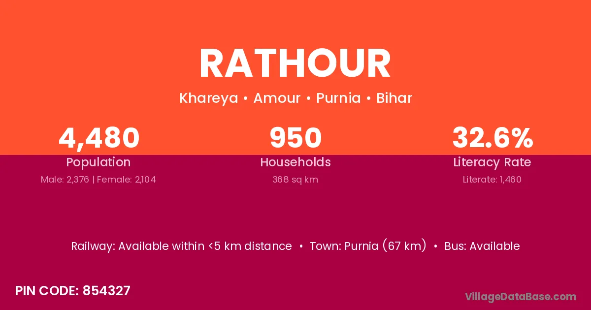
Rathour village is located in the Amour Subdivision of the Purnia district in Bihar .

Rathour

About Rathour Village

Block / Subdivision → Amour

District → Purnia

State → Bihar

According to Census 2011 information, the village code of Rathour village is 854327.

Rathour village has a total population of 4,480 people, of which 2,376 are males and 2,104 are females.

The literacy rate of Rathour village is 32.59%. Male literacy stands at 39.94% and female literacy at 24.29%.

There are approximately 950 households in Rathour village.

Purnia (67 km) is the nearest town to Rathour village for major economic activities and is located approximately 67 km away.

Population of Rathour Village

The population of Rathour village is distributed between literate and illiterate residents as follows:

Population distribution of Rathour village by literacy and gender
Particulars Male Female Total
Literate 949 511 1,460
Illiterate 1,427 1,593 3,020
Total 2,376 2,104 4,480

Source: Census 2011

Nearby Villages

List of nearby villages around Rathour village
Village District
Araria Araria
Araria Khagaria
Araria Pashchim Champaran
Araria Purnia
Araria Sitamarhi
Araria Deoghar
Araria Kodarma
Bagdahar Purnia
Baghua Gachh Purnia
Baghua Kola Purnia
Belka Purnia
Belka Guna
Dolmalpur Purnia
Dolmalpur Maldah
Dolmalpur Maldah
Gerua Baksa
Gerua Baksa
Gerua Goalpara
Gerua Kamrup
Gerua Udalguri
Gerua Aurangabad
Gerua Purnia
Gerua Chatra
Gerua Chatra
Gerua Palamu
Gerua Purbi Singhbhum
Gerua Raisen
Gerua Mirzapur
Gerua Uttar Dinajpur
Karia Nalbari
Karia Purnia
Karia Mahendragarh
Karia Panna
Karia Gorakhpur
Karia Sonbhadra
Karia Varanasi
Karia Haora
Karia Paschim Medinipur
Kharhia Purnia
Kharhia Kanshiram Nagar
Madhua Kola Purnia
Majhua Araria
Majhua Araria
Majhua Araria
Majhua Purnia
Majhua Purnia
Majhua Purnia

Frequently Asked Questions

Rathour village is located in the Amour Subdivision of the Purnia district in Bihar.
The total population is 4,480 people.
2,376 males and 2,104 females.
The literacy rate is 32.59%.
Male literacy rate is 39.94%, and female literacy rate is 24.29%.
There are approximately 950 houses in Rathour village.
Purnia (67 km) is the nearest town, located approximately 67 km away.

Reviews and Ratings

0.0 / 5 (0 reviews)

Reviews

No reviews yet. Be the first to review this village!

Rathour Village Statistics

Population
4480
Area
368 km²
Households
950
Nearest Town :
Purnia (67 km)

Quick Information

State / UT : Bihar
Pincode : 854327
Total Area : 368 km²
Population : 4480
Households : 950
Gram Panchayat : Khareya
Nearest Town : Purnia (67 km)

Connectivity of Rathour

🚂 Railway Station

Available within <5 km distance

🚌 Public Bus Service

Available within <5 km distance

🚌 Private Bus Service

Available within 5 - 10 km distance

Need Help?