Welcome Back

Forgot password?
Don't have an account?
🏘️ Menu
Koriya District 0.0 / 5 (0)

Umarwah Village Detailed Information

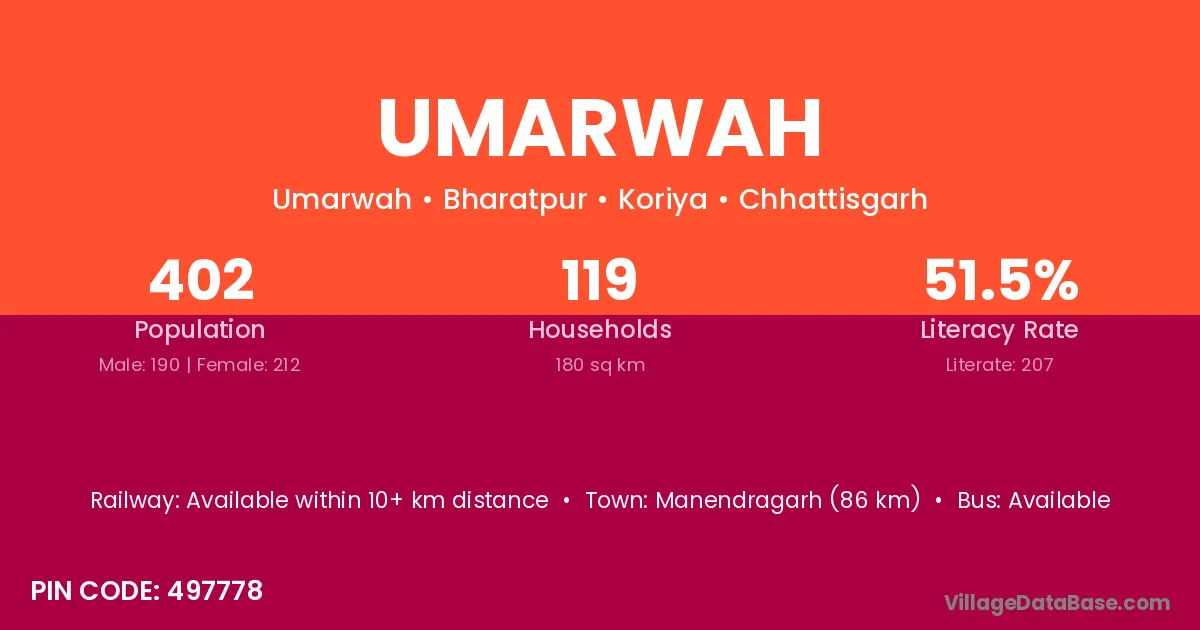
Umarwah village is located in the Bharatpur Tehsil of the Koriya district in Chhattisgarh .

About Umarwah Village

Block / Tehsil → Bharatpur

District → Koriya

State → Chhattisgarh

According to Census 2011 information, the village code of Umarwah village is 497778.

Umarwah village has a total population of 402 people, of which 190 are males and 212 are females.

The literacy rate of Umarwah village is 51.49%. Male literacy stands at 62.11% and female literacy at 41.98%.

There are approximately 119 households in Umarwah village.

Manendragarh (86 km) is the nearest town to Umarwah village for major economic activities and is located approximately 86 km away.

Population of Umarwah Village

The population of Umarwah village is distributed between literate and illiterate residents as follows:

Population distribution of Umarwah village by literacy and gender
Particulars Male Female Total
Literate 118 89 207
Illiterate 72 123 195
Total 190 212 402

Source: Census 2011

Nearby Villages

List of nearby villages around Umarwah village
Village District
Benipura Koriya
Benipura Gwalior
Benipura Sheopur
Bhawarkhoh Koriya
Chutki Koriya
Dandwajhar Koriya
Dhobatal Koriya
Harri Madhubani
Harri Sitamarhi
Harri Bilaspur
Harri Jashpur
Harri Koriya
Harri Surguja
Harri Gumla
Harri Anuppur
Harri Anuppur
Harri Shahdol
Harri Shahdol
Harri Chitrakoot
Harri Hardoi
Karimati Kabeerdham
Karimati Korba
Karimati Koriya
Karimati Surguja
Karimati Hazaribagh
Karimati Hazaribagh
Karimati Simdega
Karimati Satna
Karimati Sidhi
Karimati Sidhi
Karimati Umaria
Karimati Sundargarh
Khetauli Koriya
Khetauli Shahdol
Khetauli Hardoi
Manaura Rohtas
Manaura Bilaspur
Manaura Koriya
Manaura Anuppur
Manaura Satna
Manaura Bara Banki
Manaura Etah
Manaura Mahamaya Nagar
Mantoliya Koriya
Mantoliya Anuppur
Pichhaura Bandh Koriya

Frequently Asked Questions

Umarwah village is located in the Bharatpur Tehsil of the Koriya district in Chhattisgarh.
The total population is 402 people.
190 males and 212 females.
The literacy rate is 51.49%.
Male literacy rate is 62.11%, and female literacy rate is 41.98%.
There are approximately 119 houses in Umarwah village.
Manendragarh (86 km) is the nearest town, located approximately 86 km away.

Reviews and Ratings

0.0 / 5 (0 reviews)

Reviews

No reviews yet. Be the first to review this village!

Umarwah Village Statistics

Population
402
Area
180 km²
Households
119
Nearest Town :
Manendragarh (86 km)

Quick Information

State / UT : Chhattisgarh
Pincode : 497778
Total Area : 180 km²
Population : 402
Households : 119
Gram Panchayat : Umarwah
Nearest Town : Manendragarh (86 km)

Connectivity of Umarwah

🚂 Railway Station

Available within 10+ km distance

🚌 Public Bus Service

Available

🚌 Private Bus Service

Available within village

Need Help?

Contact local tourism office for assistance