Welcome Back

Forgot password?
Don't have an account?
🏘️ Menu
Kupwara District 0.0 / 5 (0)

Harel Village Detailed Information

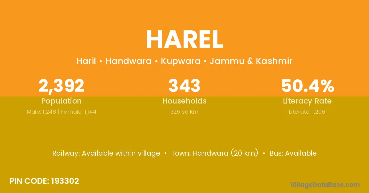
Harel village is located in the Handwara Tehsil of the Kupwara district in Jammu & Kashmir .

Harel

About Harel Village

Block / Tehsil → Handwara

District → Kupwara

State → Jammu & Kashmir

According to Census 2011 information, the village code of Harel village is 193302.

Harel village has a total population of 2,392 people, of which 1,248 are males and 1,144 are females.

The literacy rate of Harel village is 50.42%. Male literacy stands at 58.09% and female literacy at 42.05%.

There are approximately 343 households in Harel village.

Handwara (20 km) is the nearest town to Harel village for major economic activities and is located approximately 20 km away.

Population of Harel Village

The population of Harel village is distributed between literate and illiterate residents as follows:

Population distribution of Harel village by literacy and gender
Particulars Male Female Total
Literate 725 481 1,206
Illiterate 523 663 1,186
Total 1,248 1,144 2,392

Source: Census 2011

Nearby Villages

List of nearby villages around Harel village
Village District
Bandi Vadodara
Bandi Kangra
Bandi Baramula
Bandi Kupwara
Bandi Hazaribagh
Bandi Pashchimi Singhbhum
Bandi Saraikela Kharsawan
Bandi Koppal
Bandi Dewas
Bandi Harda
Bandi Hoshangabad
Bandi Rajgarh
Bandi Sagar
Bandi Satna
Bandi Sheopur
Bandi Bathinda
Bandi Basti
Bandi Mahrajganj
Bandi Mathura
Bandi Shahjahanpur
Bandi Birbhum
Bandi Darjiling
Bandi Paschim Medinipur
Bandi Puruliya
Bandi Paschim Medinipur
Bandi Puruliya
Darabal Pain Kupwara
Duda Kuhl Kupwara
Gund Razak Kupwara
Haider Mari Kupwara
Jahama Badgam
Jahama Baramula
Jahama Kupwara
Khudi Golaghat
Khudi Bastar
Khudi Mandi
Khudi Mandi
Khudi Kupwara
Khudi Sindhudurg
Khudi Gurdaspur
Lohikot Kupwara
Moona Bal Kupwara
Sheikh Pora Anantnag
Sheikh Pora Badgam
Sheikh Pora Baramula
Sheikh Pora Kupwara
Shil Thra Kupwara

Frequently Asked Questions

Harel village is located in the Handwara Tehsil of the Kupwara district in Jammu & Kashmir.
The total population is 2,392 people.
1,248 males and 1,144 females.
The literacy rate is 50.42%.
Male literacy rate is 58.09%, and female literacy rate is 42.05%.
There are approximately 343 houses in Harel village.
Handwara (20 km) is the nearest town, located approximately 20 km away.

Reviews and Ratings

0.0 / 5 (0 reviews)

Reviews

No reviews yet. Be the first to review this village!

Harel Village Statistics

Population
2392
Area
325 km²
Households
343
Nearest Town :
Handwara (20 km)

Quick Information

State / UT : Jammu & Kashmir
Pincode : 193302
Total Area : 325 km²
Population : 2392
Households : 343
Gram Panchayat : Haril
Nearest Town : Handwara (20 km)

Connectivity of Harel

🚂 Railway Station

Available within village

🚌 Public Bus Service

Available within 10+ km distance

🚌 Private Bus Service

Available within 10+ km distance

Need Help?