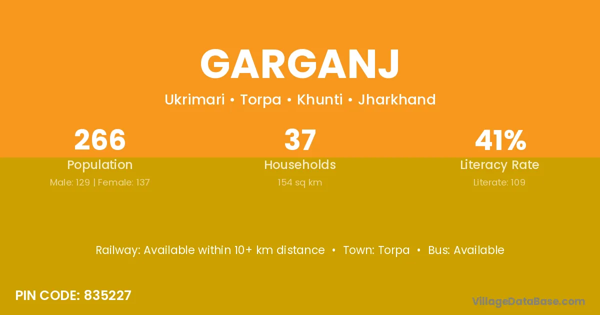
Garganj village is located in the Torpa Subdivision of the Khunti district in Jharkhand .
Block / Subdivision → Torpa
District → Khunti
State → Jharkhand
According to Census 2011 information, the village code of Garganj village is 835227.
Garganj village has a total population of 266 people, of which 129 are males and 137 are females.
The literacy rate of Garganj village is 40.98%. Male literacy stands at 54.26% and female literacy at 28.47%.
There are approximately 37 households in Garganj village.
Torpa is the nearest town to Garganj village for major economic activities
The population of Garganj village is distributed between literate and illiterate residents as follows:
| Particulars | Male | Female | Total |
|---|---|---|---|
| Literate | 70 | 39 | 109 |
| Illiterate | 59 | 98 | 157 |
| Total | 129 | 137 | 266 |
Source: Census 2011
| Village | District |
|---|---|
| Budu | Khunti |
| Dhobisoso | Khunti |
| Digri | Dhanbad |
| Digri | Khunti |
| Digri | Khunti |
| Digri | Khunti |
| Digri | Purbi Singhbhum |
| Digri | Jaisalmer |
| Digri | Nadia |
| Digri | Paschim Medinipur |
| Digri | Nadia |
| Digri | Paschim Medinipur |
| Diyankel | Khunti |
| Ermere | Khunti |
| Girung | Khunti |
| Icha | Gumla |
| Icha | Khunti |
| Icha | Saraikela Kharsawan |
| Icha | Washim |
| Jhatnitola | Khunti |
| Jogisoso | Khunti |
| Tati | Gumla |
| Tati | Gumla |
| Tati | Hazaribagh |
| Tati | Khunti |
| Tati | Lohardaga |
| Tati | Lohardaga |
| Tati | Ranchi |
| Tati | Ranchi |
| Tati | Simdega |
| Ukrimanri | Khunti |
No reviews yet. Be the first to review this village!
Available within 10+ km distance
Available within 5 - 10 km distance
Available within 5 - 10 km distance