Welcome Back

Forgot password?
Don't have an account?
🏘️ Menu
Seoni District 0.0 / 5 (0)

Umarwada Village Detailed Information

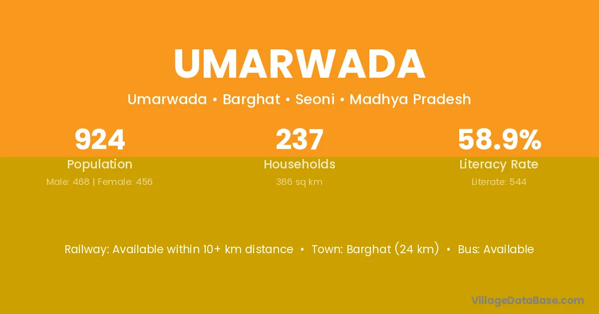
Umarwada village is located in the Barghat Tehsil of the Seoni district in Madhya Pradesh .

About Umarwada Village

Block / Tehsil → Barghat

District → Seoni

State → Madhya Pradesh

Umarwada village has a total population of 924 people, of which 468 are males and 456 are females.

The literacy rate of Umarwada village is 58.87%. Male literacy stands at 69.87% and female literacy at 47.59%.

There are approximately 237 households in Umarwada village.

Barghat (24 km) is the nearest town to Umarwada village for major economic activities and is located approximately 24 km away.

Population of Umarwada Village

The population of Umarwada village is distributed between literate and illiterate residents as follows:

Population distribution of Umarwada village by literacy and gender
Particulars Male Female Total
Literate 327 217 544
Illiterate 141 239 380
Total 468 456 924

Source: Census 2011

Nearby Villages

List of nearby villages around Umarwada village
Village District
Behrai Seoni
Chamarwahi Balaghat
Chamarwahi Mandla
Chamarwahi Seoni
Dorli Balaghat
Dorli Balaghat
Dorli Balaghat
Dorli Balaghat
Dorli Balaghat
Dorli Chhindwara
Dorli Chhindwara
Dorli Seoni
Dorli Chandrapur
Dorli Nagpur
Dorli Nagpur
Dorli Nagpur
Dorli Nanded
Dorli Nanded
Dorli Sangli
Dorli Sangli
Dorli Wardha
Dorli Wardha
Dorli Yavatmal
Dorli Yavatmal
Dorli Yavatmal
Dorli Yavatmal
Dorli Yavatmal
Dorli Yavatmal
Dorli Yavatmal
Dorli Kota
Dorli Adilabad
Ghisi Seoni
Ghurwada Mandla
Ghurwada Seoni
Ghurwada Seoni
Ghurwada Seoni
Godegaon Seoni
Godegaon Seoni
Latgaon Chhindwara
Latgaon Seoni
Mau Aurangabad
Mau Gaya
Mau Durg
Mau Sabar Kantha
Mau Balaghat
Mau Chhatarpur
Mau Chhatarpur
Mau Chhindwara
Mau Datia
Mau Guna
Mau Gwalior
Mau Narsimhapur
Mau Rajgarh
Mau Ratlam
Mau Rewa
Mau Rewa
Mau Sagar
Mau Satna
Mau Seoni
Mau Shahdol
Mau Sheopur
Mau Shivpuri
Mau Sidhi
Mau Sidhi
Mau Tikamgarh
Mau Pune
Mau Jalandhar
Mau Alwar
Mau Baran
Mau Pratapgarh
Mau Pratapgarh
Mau Rajsamand
Mau Sikar
Mau Agra
Mau Aligarh
Mau Auraiya
Mau Banda
Mau Bara Banki
Mau Bulandshahr
Mau Chitrakoot
Mau Faizabad
Mau Fatehpur
Mau Gonda
Mau Hardoi
Mau Jalaun
Mau Kanpur Dehat
Mau Lalitpur
Mau Lucknow
Mau Moradabad
Mau Pratapgarh
Mau Rae Bareli
Mau Rae Bareli
Mau Rampur
Mau Siddharthnagar
Mau Sitapur
Mau Sultanpur
Mau Sultanpur
Mau Unnao
Mau Champawat
Mohgaon Durg
Mohgaon Janjgir Champa
Mohgaon Kabeerdham
Mohgaon Kabeerdham
Mohgaon Kabeerdham
Mohgaon Mahasamund
Mohgaon Mahasamund
Mohgaon Mahasamund
Mohgaon Raipur
Mohgaon Raipur
Mohgaon Rajnandgaon
Mohgaon Rajnandgaon
Mohgaon Rajnandgaon
Mohgaon Uttar Bastar Kanker
Mohgaon Balaghat
Mohgaon Balaghat
Mohgaon Balaghat
Mohgaon Balaghat
Mohgaon Betul
Mohgaon Chhindwara
Mohgaon Chhindwara
Mohgaon Chhindwara
Mohgaon Hoshangabad
Mohgaon Hoshangabad
Mohgaon Mandla
Mohgaon Mandla
Mohgaon Mandla
Mohgaon Mandla
Mohgaon Mandla
Mohgaon Seoni
Mohgaon Seoni
Mohgaon Seoni
Mohgaon Seoni
Mohgaon Seoni
Mohgaon Seoni
Mohgaon Seoni
Mohgaon Bhandara
Mohgaon Gondiya
Mohgaon Gondiya
Mohgaon Gondiya
Mohgaon Latur
Mohgaon Latur
Mohgaon Nagpur
Mohgaon Nagpur
Mohgaon Nagpur
Mohgaon Nagpur
Mohgaon Nagpur
Mohgaon Wardha
Mohgaon Wardha
Mohgaon Washim
Nandi Mandi
Nandi Belgaum
Nandi Chikkaballapura
Nandi Chikmagalur
Nandi Balaghat
Nandi Dewas
Nandi Seoni
Nandi Jalna
Nandi Rayagada
Nandi Chitrakoot
Nandi Tehri Garhwal
Saila Korba
Saila Korba
Saila Balaghat
Saila Seoni

Frequently Asked Questions

Umarwada village is located in the Barghat Tehsil of the Seoni district in Madhya Pradesh.
The total population is 924 people.
468 males and 456 females.
The literacy rate is 58.87%.
Male literacy rate is 69.87%, and female literacy rate is 47.59%.
There are approximately 237 houses in Umarwada village.
Barghat (24 km) is the nearest town, located approximately 24 km away.

Reviews and Ratings

0.0 / 5 (0 reviews)

Reviews

No reviews yet. Be the first to review this village!

Umarwada Village Statistics

Population
924
Area
386 km²
Households
237
Nearest Town :
Barghat (24 km)

Quick Information

State / UT : Madhya Pradesh
Total Area : 386 km²
Population : 924
Households : 237
Gram Panchayat : Umarwada
Nearest Town : Barghat (24 km)

Connectivity of Umarwada

🚂 Railway Station

Available within 10+ km distance

🚌 Public Bus Service

Available within 5 - 10 km distance

🚌 Private Bus Service

Available within 5 - 10 km distance

Need Help?

Contact local tourism office for assistance