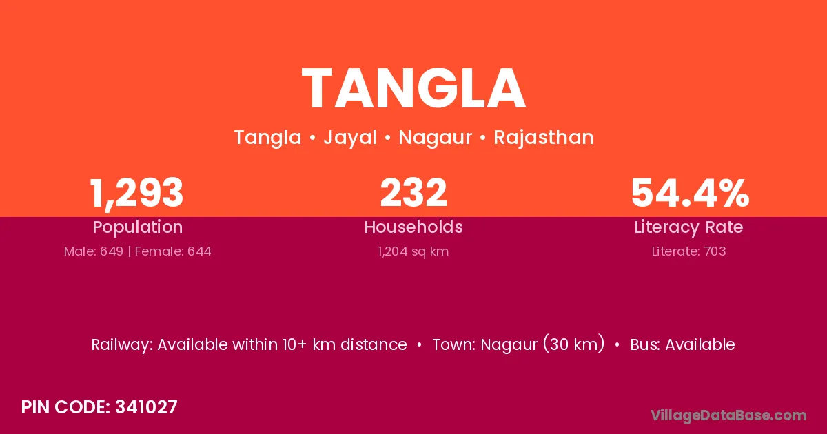
Tangla village is located in the Jayal Tehsil of the Nagaur district in Rajasthan .
Block / Tehsil → Jayal
District → Nagaur
State → Rajasthan
According to Census 2011 information, the village code of Tangla village is 341027.
Tangla village has a total population of 1,293 people, of which 649 are males and 644 are females.
The literacy rate of Tangla village is 54.37%. Male literacy stands at 70.11% and female literacy at 38.51%.
There are approximately 232 households in Tangla village.
Nagaur (30 km) is the nearest town to Tangla village for major economic activities and is located approximately 30 km away.
The population of Tangla village is distributed between literate and illiterate residents as follows:
| Particulars | Male | Female | Total |
|---|---|---|---|
| Literate | 455 | 248 | 703 |
| Illiterate | 194 | 396 | 590 |
| Total | 649 | 644 | 1,293 |
Source: Census 2011
| Village | District |
|---|---|
| Bodind Khurd | Nagaur |
| Chhawata Khurd | Nagaur |
| Deediya Kalan | Nagaur |
| Deediya Khurd | Nagaur |
| Dharna | Yavatmal |
| Dharna | Barmer |
| Dharna | Nagaur |
| Dharna | Pratapgarh |
| Jhalalar | Nagaur |
| Kherwar | Nagaur |
| Kusiya | Nagaur |
| Phardod | Nagaur |
| Rol | Kabeerdham |
| Rol | Chatra |
| Rol | Hazaribagh |
| Rol | Latehar |
| Rol | Latehar |
| Rol | Palamu |
| Rol | Ranchi |
| Rol | Ranchi |
| Rol | Balaghat |
| Rol | Nagaur |
| Rol | Bankura |
| Rooniya | Nagaur |
No reviews yet. Be the first to review this village!
Available within 10+ km distance
Available within <5 km distance
Available within <5 km distance