Welcome Back

Forgot password?
Don't have an account?
🏘️ Menu
Gorakhpur District 0.0 / 5 (0)

Bangla Panday Village Detailed Information

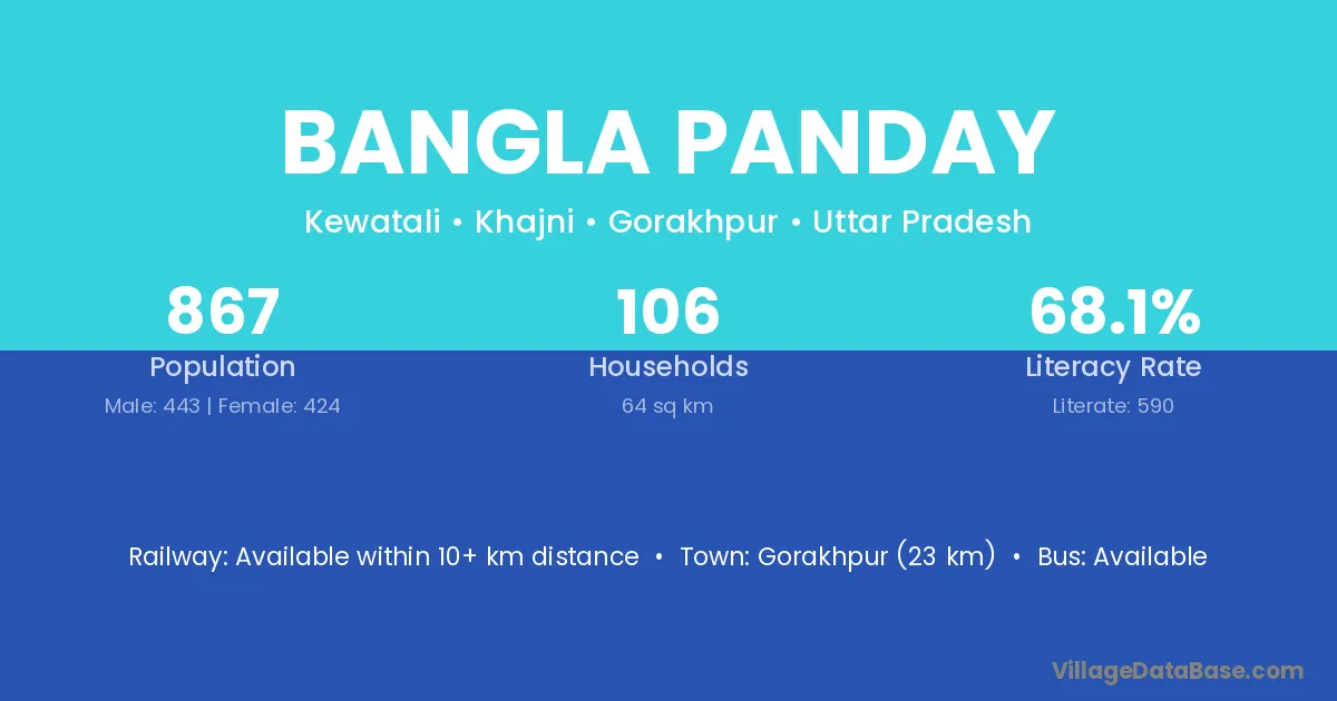
Bangla Panday village is located in the Khajni Tehsil of the Gorakhpur district in Uttar Pradesh .

About Bangla Panday Village

Block / Tehsil → Khajni

District → Gorakhpur

State → Uttar Pradesh

Bangla Panday village has a total population of 867 people, of which 443 are males and 424 are females.

The literacy rate of Bangla Panday village is 68.05%. Male literacy stands at 74.72% and female literacy at 61.08%.

There are approximately 106 households in Bangla Panday village.

Gorakhpur (23 km) is the nearest town to Bangla Panday village for major economic activities and is located approximately 23 km away.

Population of Bangla Panday Village

The population of Bangla Panday village is distributed between literate and illiterate residents as follows:

Population distribution of Bangla Panday village by literacy and gender
Particulars Male Female Total
Literate 331 259 590
Illiterate 112 165 277
Total 443 424 867

Source: Census 2011

Nearby Villages

List of nearby villages around Bangla Panday village
Village District
Laxmipur North & Middle Andaman
Sahijana Kaimur
Laxmipur Koriya
Laxmipur Mahasamund
Laxmipur Raigarh
Laxmipur Surguja
Babhana Surguja
Laxmipur Surguja
Laxmipur Uttar Bastar Kanker
Sahijana Gumla
Sahijana Hazaribagh
Laxmipur Haveri
Laxmipur Koppal
Laxmipur Panna
Sahijana Rewa
Sahijana Rewa
Urua Rewa
Sahijana Satna
Sahijana Umaria
Laxmipur Bid
Laxmipur Gadchiroli
Laxmipur Gadchiroli
Laxmipur Wardha
Laxmipur Anugul
Laxmipur Baudh
Laxmipur Debagarh
Laxmipur Debagarh
Laxmipur Gajapati
Laxmipur Gajapati
Laxmipur Ganjam
Laxmipur Ganjam
Laxmipur Ganjam
Laxmipur Kalahandi
Laxmipur Kendujhar
Laxmipur Mayurbhanj
Laxmipur Rayagada
Laxmipur Rayagada
Laxmipur Rayagada
Laxmipur Rayagada
Binawala Dausa
Laxmipur Adilabad
Laxmipur Adilabad
Laxmipur Adilabad
Laxmipur Adilabad
Laxmipur Adilabad
Laxmipur Karimnagar
Laxmipur Karimnagar
Laxmipur Karimnagar
Laxmipur Mahbubnagar
Laxmipur Warangal
Laxmipur Warangal
Laxmipur Dhalai
Laxmipur North Tripura
Laxmipur South Tripura
Laxmipur West Tripura
Laxmipur Azamgarh
Sahijana Azamgarh
Laxmipur Bareilly
Laxmipur Bareilly
Laxmipur Budaun
Babhana Deoria
Laxmipur Deoria
Laxmipur Deoria
Laxmipur Deoria
Laxmipur Deoria
Laxmipur Deoria
Laxmipur Gonda
Laxmipur Gorakhpur
Babhana Gorakhpur
Binawala Gorakhpur
Bishhunpur Gorakhpur
Chakbagla Gorakhpur
Jhudiya Gorakhpur
Kewatale Gorakhpur
Laxmipur Gorakhpur
Rampur Panday Gorakhpur
Sahijana Gorakhpur
Urua Gorakhpur
Usarapar Gorakhpur
Sahijana Hardoi
Sahijana Hardoi
Sahijana Hardoi
Sahijana Hardoi
Sahijana Kheri
Laxmipur Kushinagar
Laxmipur Kushinagar
Laxmipur Kushinagar
Sahijana Lucknow
Laxmipur Mahrajganj
Laxmipur Mahrajganj
Laxmipur Mainpuri
Laxmipur Mau
Urua Mirzapur
Laxmipur Shahjahanpur
Babhana Unnao
Laxmipur Udham Singh Nagar

Frequently Asked Questions

Bangla Panday village is located in the Khajni Tehsil of the Gorakhpur district in Uttar Pradesh.
The total population is 867 people.
443 males and 424 females.
The literacy rate is 68.05%.
Male literacy rate is 74.72%, and female literacy rate is 61.08%.
There are approximately 106 houses in Bangla Panday village.
Gorakhpur (23 km) is the nearest town, located approximately 23 km away.

Reviews and Ratings

0.0 / 5 (0 reviews)

Reviews

No reviews yet. Be the first to review this village!

Bangla Panday Village Statistics

Population
867
Area
64 km²
Households
106
Nearest Town :
Gorakhpur (23 km)

Quick Information

State / UT : Uttar Pradesh
Total Area : 64 km²
Population : 867
Households : 106
Gram Panchayat : Kewatali
Nearest Town : Gorakhpur (23 km)

Connectivity of Bangla Panday

🚂 Railway Station

Available within 10+ km distance

🚌 Public Bus Service

Available within <5 km distance

🚌 Private Bus Service

Available

Need Help?

Contact local tourism office for assistance