Welcome Back

Forgot password?
Don't have an account?
🏘️ Menu
Sitapur District 0.0 / 5 (0)

Umra Kala Village Detailed Information

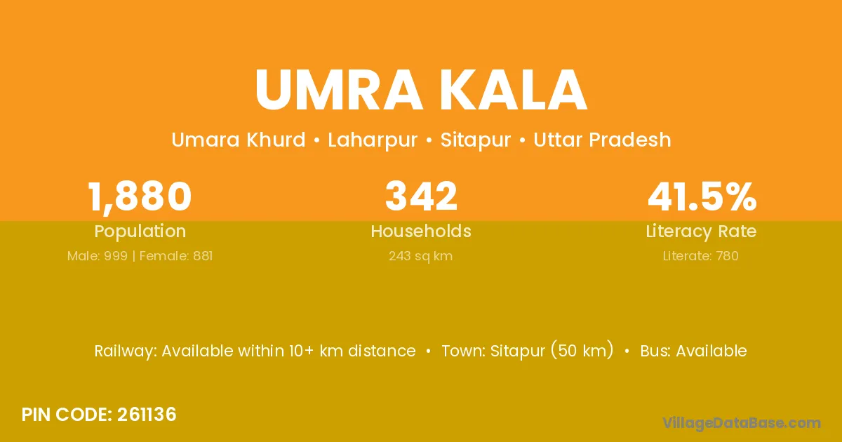
Umra Kala village is located in the Laharpur Tehsil of the Sitapur district in Uttar Pradesh .

About Umra Kala Village

Block / Tehsil → Laharpur

District → Sitapur

State → Uttar Pradesh

According to Census 2011 information, the village code of Umra Kala village is 261136.

Umra Kala village has a total population of 1,880 people, of which 999 are males and 881 are females.

The literacy rate of Umra Kala village is 41.49%. Male literacy stands at 50.25% and female literacy at 31.56%.

There are approximately 342 households in Umra Kala village.

Sitapur (50 km) is the nearest town to Umra Kala village for major economic activities and is located approximately 50 km away.

Population of Umra Kala Village

The population of Umra Kala village is distributed between literate and illiterate residents as follows:

Population distribution of Umra Kala village by literacy and gender
Particulars Male Female Total
Literate 502 278 780
Illiterate 497 603 1,100
Total 999 881 1,880

Source: Census 2011

Nearby Villages

List of nearby villages around Umra Kala village
Village District
Bariari Saharsa
Bariari Sitapur
Chiliha Sitapur
Dugana Sitapur
Gagalapur Sitapur
Kajipur Mahesana
Kajipur Panna
Kajipur Aurangabad
Kajipur Khordha
Kajipur Allahabad
Kajipur Allahabad
Kajipur Ballia
Kajipur Basti
Kajipur Chandauli
Kajipur Gonda
Kajipur Hardoi
Kajipur Jaunpur
Kajipur Mau
Kajipur Pratapgarh
Kajipur Sant Kabir Nagar
Kajipur Sitapur
Kalli Uttara Kannada
Kalli Sitapur
Kalli Sitapur
Lakhua Behad Sitapur
Madnapur Chandrapur
Madnapur Nagpur
Madnapur Nanded
Madnapur Nanded
Madnapur Adilabad
Madnapur Nalgonda
Madnapur Bara Banki
Madnapur Bareilly
Madnapur Bareilly
Madnapur Hardoi
Madnapur Hardoi
Madnapur Moradabad
Madnapur Rae Bareli
Madnapur Shahjahanpur
Madnapur Sitapur
Madnapur Paschim Medinipur
Pyarapur Sitapur
Sakaran Sitapur
Sakaran Sitapur
Umra Khurd Sitapur

Frequently Asked Questions

Umra Kala village is located in the Laharpur Tehsil of the Sitapur district in Uttar Pradesh.
The total population is 1,880 people.
999 males and 881 females.
The literacy rate is 41.49%.
Male literacy rate is 50.25%, and female literacy rate is 31.56%.
There are approximately 342 houses in Umra Kala village.
Sitapur (50 km) is the nearest town, located approximately 50 km away.

Reviews and Ratings

0.0 / 5 (0 reviews)

Reviews

No reviews yet. Be the first to review this village!

Umra Kala Village Statistics

Population
1880
Area
243 km²
Households
342
Nearest Town :
Sitapur (50 km)

Quick Information

State / UT : Uttar Pradesh
Pincode : 261136
Total Area : 243 km²
Population : 1880
Households : 342
Gram Panchayat : Umara Khurd
Nearest Town : Sitapur (50 km)

Connectivity of Umra Kala

🚂 Railway Station

Available within 10+ km distance

🚌 Public Bus Service

Available within 10+ km distance

🚌 Private Bus Service

Available within village

Need Help?

Contact local tourism office for assistance