Welcome Back

Forgot password?
Don't have an account?
🏘️ Menu
Hugli District 0.0 / 5 (0)

Puin Village Detailed Information

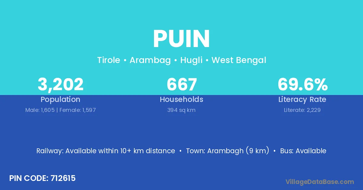
Puin village is located in the Arambag Subdivision of the Hugli district in West Bengal .

About Puin Village

Block / Subdivision → Arambag

District → Hugli

State → West Bengal

According to Census 2011 information, the village code of Puin village is 712615.

Puin village has a total population of 3,202 people, of which 1,605 are males and 1,597 are females.

The literacy rate of Puin village is 69.61%. Male literacy stands at 74.89% and female literacy at 64.31%.

There are approximately 667 households in Puin village.

Arambagh (9 km) is the nearest town to Puin village for major economic activities and is located approximately 9 km away.

Population of Puin Village

The population of Puin village is distributed between literate and illiterate residents as follows:

Population distribution of Puin village by literacy and gender
Particulars Male Female Total
Literate 1,202 1,027 2,229
Illiterate 403 570 973
Total 1,605 1,597 3,202

Source: Census 2011

Nearby Villages

List of nearby villages around Puin village
Village District
Benga Araria
Benga Begusarai
Benga Barddhaman
Benga Hugli
Benga Puruliya
Benga Puruliya
Bora Bhagalpur
Bora Fatehabad
Bora Dumka
Bora Saraikela Kharsawan
Bora Balaghat
Bora Gondiya
Bora Hoshiarpur
Bora Barddhaman
Bora Dakshin Dinajpur
Bora Hugli
Bora Paschim Medinipur
Chak Jalal Patna
Chak Jalal Samastipur
Chak Jalal Saran
Chak Jalal Vaishali
Chak Jalal Azamgarh
Chak Jalal Ballia
Chak Jalal Bijnor
Chak Jalal Gorakhpur
Chak Jalal Kanpur Dehat
Chak Jalal Dakshin Dinajpur
Chak Jalal Hugli
Chak Madan Hugli
Chandibati Barddhaman
Chandibati Hugli
Chandibati Murshidabad
Donga Bathan Hugli
Eadpur Hugli
Karui Garhwa
Karui Barddhaman
Karui Hugli
Maigram Hugli
Ruitchak Hugli
Tirol Hugli

Frequently Asked Questions

Puin village is located in the Arambag Subdivision of the Hugli district in West Bengal.
The total population is 3,202 people.
1,605 males and 1,597 females.
The literacy rate is 69.61%.
Male literacy rate is 74.89%, and female literacy rate is 64.31%.
There are approximately 667 houses in Puin village.
Arambagh (9 km) is the nearest town, located approximately 9 km away.

Reviews and Ratings

0.0 / 5 (0 reviews)

Reviews

No reviews yet. Be the first to review this village!

Puin Village Statistics

Population
3202
Area
394 km²
Households
667
Nearest Town :
Arambagh (9 km)

Quick Information

State / UT : West Bengal
Pincode : 712615
Total Area : 394 km²
Population : 3202
Households : 667
Gram Panchayat : Tirole
Nearest Town : Arambagh (9 km)

Connectivity of Puin

🚂 Railway Station

Available within 10+ km distance

🚌 Public Bus Service

Available within village

🚌 Private Bus Service

Available within 5 - 10 km distance

Need Help?

Contact local tourism office for assistance