Welcome Back

Forgot password?
Don't have an account?
🏘️ Menu
Guntur District 0.0 / 5 (0)

Thallapalle Village Detailed Information

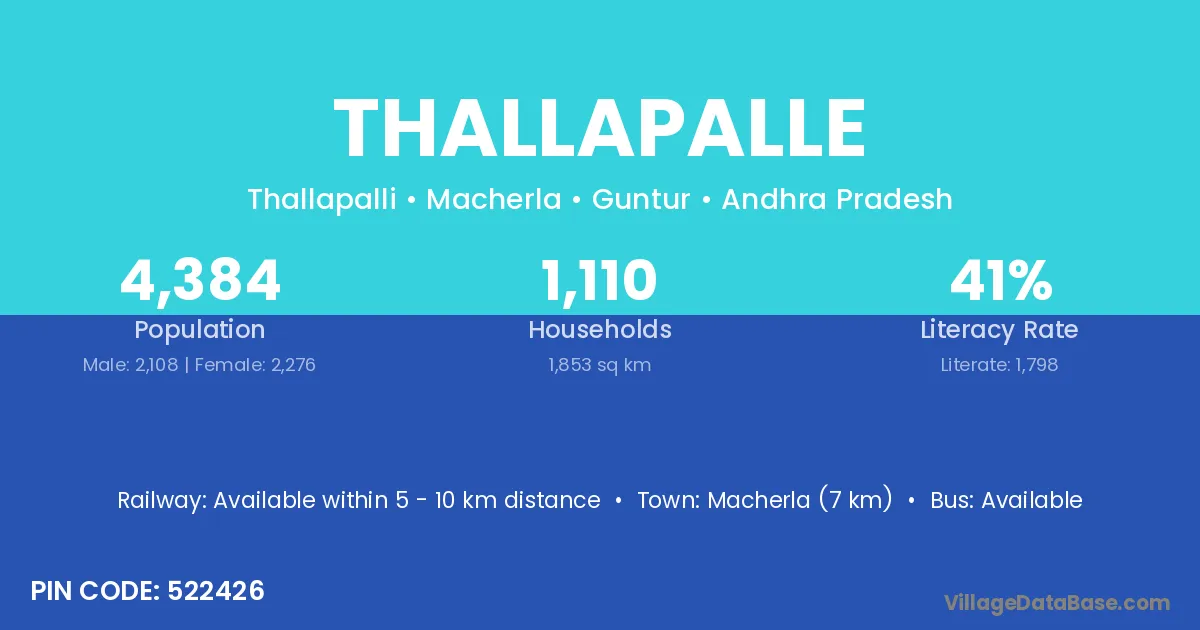
Thallapalle village is located in the Macherla Mandal of the Guntur district in Andhra Pradesh .

About Thallapalle Village

Block / Mandal → Macherla

District → Guntur

State → Andhra Pradesh

According to Census 2011 information, the village code of Thallapalle village is 522426.

Thallapalle village has a total population of 4,384 people, of which 2,108 are males and 2,276 are females.

The literacy rate of Thallapalle village is 41.01%. Male literacy stands at 49.38% and female literacy at 33.26%.

There are approximately 1,110 households in Thallapalle village.

Macherla (7 km) is the nearest town to Thallapalle village for major economic activities and is located approximately 7 km away.

Population of Thallapalle Village

The population of Thallapalle village is distributed between literate and illiterate residents as follows:

Population distribution of Thallapalle village by literacy and gender
Particulars Male Female Total
Literate 1,041 757 1,798
Illiterate 1,067 1,519 2,586
Total 2,108 2,276 4,384

Source: Census 2011

Nearby Villages

List of nearby villages around Thallapalle village
Village District
Kothapalle Anantapur
Kothapalle Chittoor
Kothapalle Chittoor
Kothapalle Chittoor
Kothapalle Chittoor
Kothapalle Chittoor
Kothapalle East Godavari
Rayavaram East Godavari
Kothapalle East Godavari
Mutyalampadu Guntur
Amani Jammala Madaka Guntur
Kambhampadu Guntur
Koppunur Guntur
Kothapalle Guntur
Macherla Guntur
Mutyalampadu Guntur
Nagulavaram Guntur
Pasuvemula Guntur
Pullareddigudem Guntur
Rayavaram Guntur
Vijayapuri South Guntur
Kambhampadu Guntur
Nagulavaram Guntur
Kothapalle Krishna
Kothapalle Krishna
Kothapalle Krishna
Rayavaram Krishna
Kothapalle Kurnool
Kothapalle Kurnool
Nagulavaram Prakasam
Kothapalle Prakasam
Rayavaram Prakasam
Rayavaram Prakasam
Kothapalle Sri Potti Sriramulu Nellore
Nagulavaram Sri Potti Sriramulu Nellore
Kothapalle Srikakulam
Kothapalle Visakhapatnam
Kothapalle Vizianagaram
Kothapalle West Godavari
Kothapalle Y S R
Kothapalle Y S R
Rayavaram Y S R
Rayavaram Pudukkottai
Kothapalle Adilabad
Kothapalle Adilabad
Kothapalle Adilabad
Kothapalle Adilabad
Kothapalle Adilabad
Kothapalle Adilabad
Kothapalle Karimnagar
Kothapalle Khammam
Kothapalle Khammam
Kothapalle Khammam
Kothapalle Mahbubnagar
Macherla Mahbubnagar
Kothapalle Mahbubnagar
Rayavaram Mahbubnagar
Kothapalle Mahbubnagar
Koppunur Mahbubnagar
Kothapalle Medak
Macherla Medak
Rayavaram Medak
Kothapalle Medak
Kothapalle Medak
Kothapalle Nalgonda
Macherla Nizamabad
Kothapalle Nizamabad
Kothapalle Rangareddy
Kothapalle Warangal
Kothapalle Warangal
Macherla Warangal
Kothapalle Warangal
Kothapalle Warangal
Kothapalle Warangal
Kothapalle Warangal

Frequently Asked Questions

Thallapalle village is located in the Macherla Mandal of the Guntur district in Andhra Pradesh.
The total population is 4,384 people.
2,108 males and 2,276 females.
The literacy rate is 41.01%.
Male literacy rate is 49.38%, and female literacy rate is 33.26%.
There are approximately 1,110 houses in Thallapalle village.
Macherla (7 km) is the nearest town, located approximately 7 km away.

Reviews and Ratings

0.0 / 5 (0 reviews)

Reviews

No reviews yet. Be the first to review this village!

Thallapalle Village Statistics

Population
4384
Area
1853 km²
Households
1110
Nearest Town :
Macherla (7 km)

Quick Information

State / UT : Andhra Pradesh
Pincode : 522426
Total Area : 1853 km²
Population : 4384
Households : 1110
Gram Panchayat : Thallapalli
Nearest Town : Macherla (7 km)

Connectivity of Thallapalle

🚂 Railway Station

Available within 5 - 10 km distance

🚌 Public Bus Service

Available within village

🚌 Private Bus Service

Available within village

Need Help?

Contact local tourism office for assistance