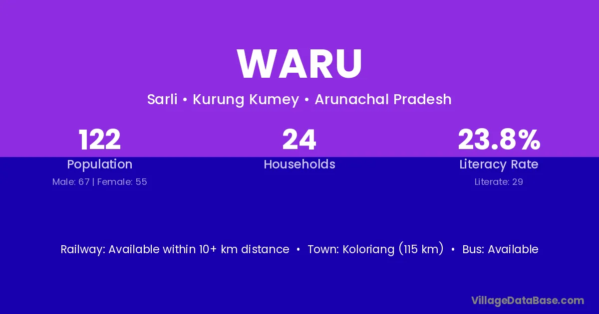
Waru village is located in the Sarli Circle of the Kurung Kumey district in Arunachal Pradesh .
Block / Circle → Sarli
District → Kurung Kumey
State → Arunachal Pradesh
Waru village has a total population of 122 people, of which 67 are males and 55 are females.
The literacy rate of Waru village is 23.77%. Male literacy stands at 31.34% and female literacy at 14.55%.
There are approximately 24 households in Waru village.
Koloriang (115 km) is the nearest town to Waru village for major economic activities and is located approximately 115 km away.
The population of Waru village is distributed between literate and illiterate residents as follows:
| Particulars | Male | Female | Total |
|---|---|---|---|
| Literate | 21 | 8 | 29 |
| Illiterate | 46 | 47 | 93 |
| Total | 67 | 55 | 122 |
Source: Census 2011
| Village | District |
|---|---|
| Bala | Kurung Kumey |
| Bala | Nalbari |
| Bala | Siwan |
| Bala | Korba |
| Bala | Koriya |
| Bala | Surendranagar |
| Bala | Bilaspur |
| Bala | Khunti |
| Bala | Dakshina Kannada |
| Bala | Kendujhar |
| Bala | Koraput |
| Bala | Mayurbhanj |
| Bala | Hoshiarpur |
| Bala | Jalor |
| Bala | Jodhpur |
| Bala | Pali |
| Bala | Allahabad |
| Bala | Rae Bareli |
| Bala | Paschim Medinipur |
| Bala | Paschim Medinipur |
| Chulu | Kurung Kumey |
| Kapu | Kurung Kumey |
| Kapu | Tirap |
| Kapu | Raigarh |
| Mangdo I | Kurung Kumey |
| Parsi Parlo H Q | Kurung Kumey |
| Riya | Kurung Kumey |
| Riya | Solan |
| Riya | Nainital |
| Sahrma | Kurung Kumey |
| Tarik | Kurung Kumey |
| Tasum | Kurung Kumey |
| Tasum | West Siang |
| Vatalin | Kurung Kumey |
| Walang | Kurung Kumey |
| Walang | Raigarh |
No reviews yet. Be the first to review this village!
Available within 10+ km distance
Available within 10+ km distance
Available within 10+ km distance