Welcome Back

Forgot password?
Don't have an account?
🏘️ Menu
Purba Champaran District 0.0 / 5 (0)

Ray Singha Village Detailed Information

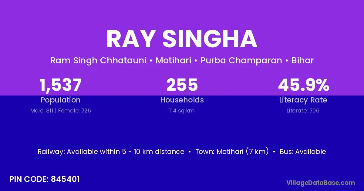
Ray Singha village is located in the Motihari Subdivision of the Purba Champaran district in Bihar .

Ray Singha

About Ray Singha Village

Block / Subdivision → Motihari

District → Purba Champaran

State → Bihar

According to Census 2011 information, the village code of Ray Singha village is 845401.

Ray Singha village has a total population of 1,537 people, of which 811 are males and 726 are females.

The literacy rate of Ray Singha village is 45.93%. Male literacy stands at 52.03% and female literacy at 39.12%.

There are approximately 255 households in Ray Singha village.

Motihari (7 km) is the nearest town to Ray Singha village for major economic activities and is located approximately 7 km away.

Population of Ray Singha Village

The population of Ray Singha village is distributed between literate and illiterate residents as follows:

Population distribution of Ray Singha village by literacy and gender
Particulars Male Female Total
Literate 422 284 706
Illiterate 389 442 831
Total 811 726 1,537

Source: Census 2011

Nearby Villages

List of nearby villages around Ray Singha village
Village District
Semra Darbhanga
Semra Gopalganj
Semra Gopalganj
Ramgarhwa Gopalganj
Semra Gopalganj
Semra Gopalganj
Semra Kaimur
Semra Kaimur
Semra Kaimur
Semra Muzaffarpur
Semra Muzaffarpur
Garahia Pashchim Champaran
Bheriharwa Pashchim Champaran
Semra Pashchim Champaran
Bheriharwa Pashchim Champaran
Semra Purba Champaran
Garahia Purba Champaran
Semra Purba Champaran
Garahia Purba Champaran
Semra Purba Champaran
Bheriharwa Purba Champaran
Chhatauni Ram Singh Purba Champaran
Garahia Purba Champaran
Gulariya Purba Champaran
Jhitkahiya Purba Champaran
Karmaula Purba Champaran
Mahangua Purba Champaran
Mahangua Tola Birtia Purba Champaran
Paterhwa Purba Champaran
Ramgarhwa Purba Champaran
Semra Purba Champaran
Bheriharwa Purba Champaran
Ramgarhwa Purba Champaran
Semra Rohtas
Semra Rohtas
Semra Rohtas
Semra Rohtas
Garahia Sheohar
Semra Siwan
Semra Bilaspur
Semra Bilaspur
Semra Dhamtari
Semra Dhamtari
Semra Dhamtari
Semra Janjgir Champa
Semra Korba
Semra Deoghar
Semra Deoghar
Semra Dumka
Semra Dumka
Semra Dumka
Semra Gumla
Semra Gumla
Semra Lohardaga
Semra Palamu
Semra Ramgarh
Semra Ranchi
Semra Ranchi
Semra Anuppur
Semra Bhind
Semra Bhind
Semra Bhopal
Semra Chhindwara
Semra Guna
Semra Guna
Semra Guna
Semra Jabalpur
Semra Narsimhapur
Semra Raisen
Semra Raisen
Semra Raisen
Ramgarhwa Rewa
Semra Satna
Semra Satna
Semra Satna
Semra Shahdol
Semra Shahdol
Semra Sheopur
Semra Shivpuri
Semra Shivpuri
Semra Sidhi
Semra Singrauli
Semra Umaria
Semra Umaria
Semra Baran
Semra Dhaulpur
Semra Agra
Semra Allahabad
Semra Ambedkar Nagar
Semra Azamgarh
Gulariya Bahraich
Semra Bahraich
Gulariya Basti
Semra Basti
Semra Basti
Semra Basti
Gulariya Budaun
Gulariya Budaun
Semra Fatehpur
Ramgarhwa Gorakhpur
Semra Gorakhpur
Semra Gorakhpur
Semra Gorakhpur
Semra Jhansi
Gulariya Jyotiba Phule Nagar
Semra Kheri
Semra Kushinagar
Semra Lucknow
Ramgarhwa Mahrajganj
Semra Mirzapur
Semra Pratapgarh
Semra Rae Bareli
Semra Sant Kabir Nagar
Semra Siddharthnagar
Gulariya Siddharthnagar
Semra Sitapur
Semra Sitapur
Gulariya Sonbhadra
Semra Sultanpur
Semra Unnao

Frequently Asked Questions

Ray Singha village is located in the Motihari Subdivision of the Purba Champaran district in Bihar.
The total population is 1,537 people.
811 males and 726 females.
The literacy rate is 45.93%.
Male literacy rate is 52.03%, and female literacy rate is 39.12%.
There are approximately 255 houses in Ray Singha village.
Motihari (7 km) is the nearest town, located approximately 7 km away.

Reviews and Ratings

0.0 / 5 (0 reviews)

Reviews

No reviews yet. Be the first to review this village!

Ray Singha Village Statistics

Population
1537
Area
114 km²
Households
255
Nearest Town :
Motihari (7 km)

Quick Information

State / UT : Bihar
Pincode : 845401
Total Area : 114 km²
Population : 1537
Households : 255
Gram Panchayat : Ram Singh Chhatauni
Nearest Town : Motihari (7 km)

Connectivity of Ray Singha

🚂 Railway Station

Available within 5 - 10 km distance

🚌 Public Bus Service

Available within 5 - 10 km distance

🚌 Private Bus Service

Available within 5 - 10 km distance

Need Help?

Contact local tourism office for assistance