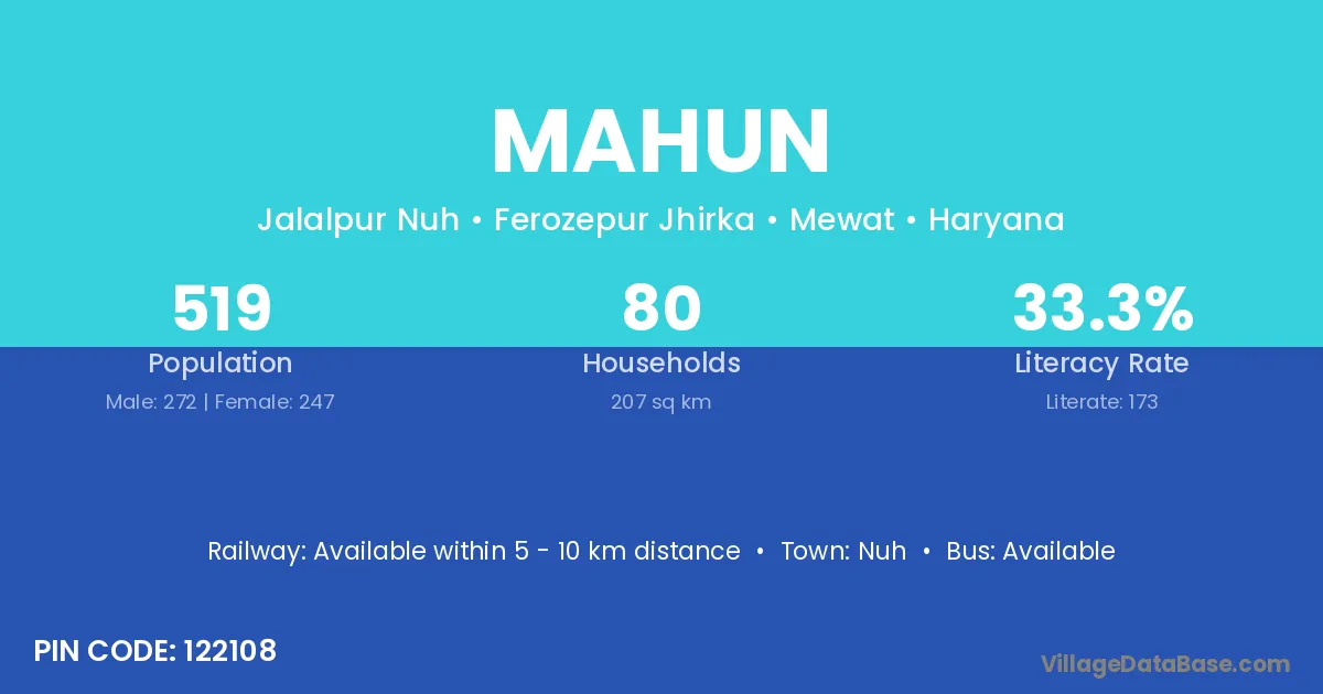
Mahun village is located in the Rakkar Tehsil of the Kangra district in Himachal Pradesh .
Block / Tehsil → Rakkar
District → Kangra
State → Himachal Pradesh
According to Census 2011 information, the village code of Mahun village is 177108.
Mahun village has a total population of 934 people, of which 472 are males and 462 are females.
The literacy rate of Mahun village is 84.58%. Male literacy stands at 89.19% and female literacy at 79.87%.
There are approximately 202 households in Mahun village.
Dera Gopipur is the nearest town to Mahun village for major economic activities
The population of Mahun village is distributed between literate and illiterate residents as follows:
| Particulars | Male | Female | Total |
|---|---|---|---|
| Literate | 421 | 369 | 790 |
| Illiterate | 51 | 93 | 144 |
| Total | 472 | 462 | 934 |
Source: Census 2011
| Village | District |
|---|---|
| Mera | Kaimur |
| Bani | Madhepura |
| Mera | Patna |
| Mera | Banas Kantha |
| Mera | Surendranagar |
| Bani | Kurukshetra |
| Bani | Sirsa |
| Garli Khas | Hamirpur |
| Bani | Hamirpur |
| Aloh Buhla | Kangra |
| Ban Sadwan | Kangra |
| Bani | Kangra |
| Dholu Bhad | Kangra |
| Garli | Kangra |
| Garli Khas | Kangra |
| Mat Umran | Kangra |
| Mera | Kangra |
| Nagrota Nahan | Kangra |
| Nahan | Kangra |
| Nathun | Kangra |
| Garli | Mandi |
| Bani | Shimla |
| Bani | Solan |
| Bani | Solan |
| Bani | Solan |
| Bani | Solan |
| Bani | Solan |
| Bani | Kathua |
| Mera | Dhanbad |
| Bani | Dhar |
| Bani | Jhabua |
| Bani | Mandsaur |
| Bani | Mandsaur |
| Bani | Morena |
| Bani | Neemuch |
| Bani | Rajgarh |
| Mera | Shivpuri |
| Bani | Ujjain |
| Bani | Cuttack |
| Nahan | Jajapur |
| Mera | Kapurthala |
| Bani | Bharatpur |
| Mera | Jalor |
| Bani | Jhalawar |
| Bani | Jhalawar |
| Bani | Allahabad |
| Bani | Budaun |
| Bani | Etah |
| Bani | Faizabad |
| Bani | Kanpur Nagar |
| Bani | Lucknow |
| Bani | Pratapgarh |
| Bani | Rae Bareli |
| Bani | Rae Bareli |
| Bani | Sultanpur |
| Bani | Unnao |
| Mera | Barddhaman |
No reviews yet. Be the first to review this village!
Available within 10+ km distance
Available within village
Available within village