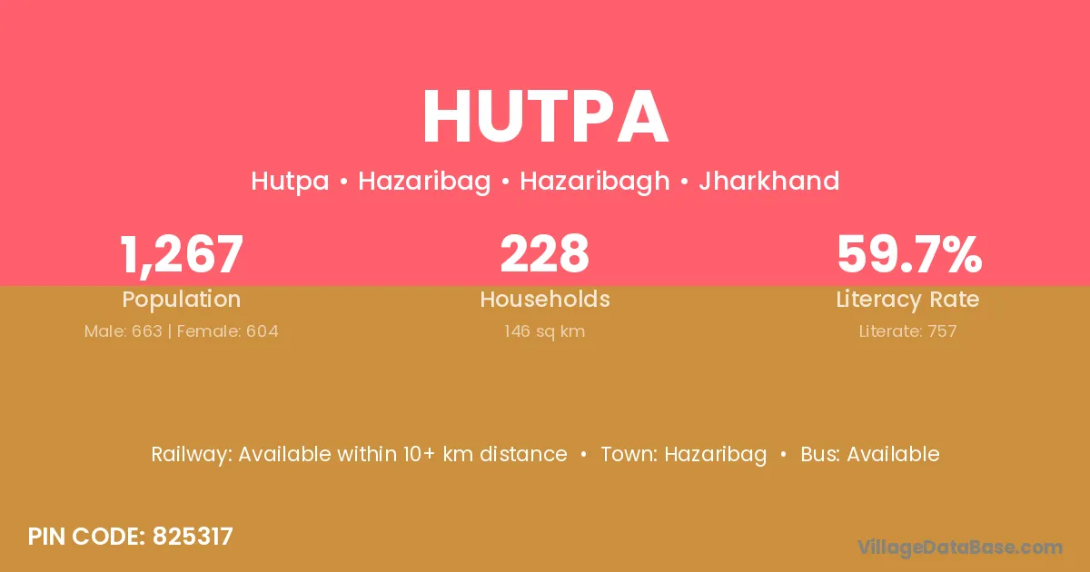
Hutpa village is located in the Hazaribag Subdivision of the Hazaribagh district in Jharkhand .
Block / Subdivision → Hazaribag
District → Hazaribagh
State → Jharkhand
According to Census 2011 information, the village code of Hutpa village is 825317.
Hutpa village has a total population of 1,267 people, of which 663 are males and 604 are females.
The literacy rate of Hutpa village is 59.75%. Male literacy stands at 69.98% and female literacy at 48.51%.
There are approximately 228 households in Hutpa village.
Hazaribag is the nearest town to Hutpa village for major economic activities
The population of Hutpa village is distributed between literate and illiterate residents as follows:
| Particulars | Male | Female | Total |
|---|---|---|---|
| Literate | 464 | 293 | 757 |
| Illiterate | 199 | 311 | 510 |
| Total | 663 | 604 | 1,267 |
Source: Census 2011
| Village | District |
|---|---|
| Banahapa | Hazaribagh |
| Barghutuwa | Hazaribagh |
| Chaya | Kaimur |
| Chaya | Chatra |
| Chaya | Hazaribagh |
| Chutiaro | Dhanbad |
| Chutiaro | Hazaribagh |
| Chutiaro | Kodarma |
| Dumar | Katihar |
| Dumar | Durg |
| Dumar | Hazaribagh |
| Dumar | Hazaribagh |
| Dumar | Hazaribagh |
| Dumar | Damoh |
| Dumar | Hoshangabad |
| Dumar | Mayurbhanj |
| Jitu | Upper Subansiri |
| Jitu | Hazaribagh |
| Jitu | Darjiling |
| Kharba | Hazaribagh |
| Kharba | Parbhani |
| Kharba | Maldah |
| Kharba | Maldah |
| Lakhaiya | Hazaribagh |
| Lakhaiya | Rewa |
| Lakhaiya | Kheri |
| Lakhaiya | Kheri |
| Rehda | Hazaribagh |
| Sarauni Kalan | Madhepura |
| Sarauni Kalan | Hazaribagh |
| Tarba | Kurung Kumey |
| Tarba | Upper Subansiri |
| Tarba | Hazaribagh |
No reviews yet. Be the first to review this village!
Available within 10+ km distance
Available within 10+ km distance
Available within 10+ km distance