Welcome Back

Forgot password?
Don't have an account?
🏘️ Menu
Bhind District 0.0 / 5 (0)

Manhad Village Detailed Information

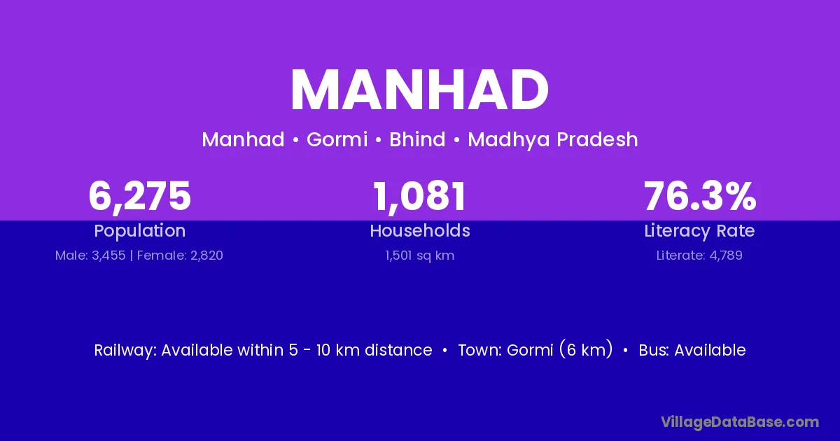
Manhad village is located in the Gormi Tehsil of the Bhind district in Madhya Pradesh .

Manhad

About Manhad Village

Block / Tehsil → Gormi

District → Bhind

State → Madhya Pradesh

Manhad village has a total population of 6,275 people, of which 3,455 are males and 2,820 are females.

The literacy rate of Manhad village is 76.32%. Male literacy stands at 80.67% and female literacy at 70.99%.

There are approximately 1,081 households in Manhad village.

Gormi (6 km) is the nearest town to Manhad village for major economic activities and is located approximately 6 km away.

Population of Manhad Village

The population of Manhad village is distributed between literate and illiterate residents as follows:

Population distribution of Manhad village by literacy and gender
Particulars Male Female Total
Literate 2,787 2,002 4,789
Illiterate 668 818 1,486
Total 3,455 2,820 6,275

Source: Census 2011

Nearby Villages

List of nearby villages around Manhad village
Village District
Chapra Barpeta
Chapra Karimganj
Chapra Aurangabad
Chapra Aurangabad
Chapra Aurangabad
Tejpura Aurangabad
Chapra Banka
Chapra Katihar
Lalpura Muzaffarpur
Lalpura Patna
Chapra Samastipur
Lalpura Vaishali
Lalpura Anand
Lalpura Banas Kantha
Tejpura Banas Kantha
Chapra Jamnagar
Tejpura Mahesana
Hirapura Panch Mahals
Chapra Ambala
Chapra Giridih
Chapra Ramgarh
Chapra Ranchi
Chapra Saraikela Kharsawan
Hirapura Bhind
Vijaygarh Bhind
Chapra Bhind
Dogarpura Bhind
Harichha Bhind
Hirapura Bhind
Kripekapura Bhind
Lalpura Bhind
Mehdoli Bhind
Raupura Bhind
Sunarpura Bhind
Tejpura Bhind
Vijaygarh Bhind
Hirapura Bhind
Lalpura Bhind
Tejpura Bhind
Lalpura Bhind
Lalpura Bhopal
Vijaygarh Chhindwara
Lalpura Damoh
Chapra Datia
Hirapura Dewas
Lalpura Dhar
Harichha Guna
Lalpura Guna
Lalpura Harda
Lalpura Indore
Lalpura Jhabua
Tejpura Jhabua
Tejpura Jhabua
Chapra Katni
Lalpura Katni
Lalpura Khandwa
Hirapura Khargone
Lalpura Khargone
Lalpura Khargone
Lalpura Khargone
Lalpura Khargone
Lalpura Mandsaur
Lalpura Morena
Vijaygarh Morena
Tejpura Neemuch
Lalpura Neemuch
Tejpura Rajgarh
Vijaygarh Rajgarh
Hirapura Rajgarh
Lalpura Rajgarh
Hirapura Rajgarh
Lalpura Rajgarh
Vijaygarh Rajgarh
Lalpura Ratlam
Lalpura Sagar
Lalpura Shajapur
Hirapura Sheopur
Hirapura Tikamgarh
Chapra Ludhiana
Lalpura Alwar
Tejpura Alwar
Lalpura Alwar
Tejpura Banswara
Lalpura Banswara
Lalpura Banswara
Lalpura Banswara
Lalpura Bhilwara
Lalpura Bhilwara
Lalpura Bundi
Lalpura Bundi
Lalpura Chittaurgarh
Tejpura Chittaurgarh
Lalpura Chittaurgarh
Lalpura Churu
Lalpura Dausa
Lalpura Dungarpur
Lalpura Jaipur
Lalpura Jaipur
Hirapura Jaipur
Lalpura Jaipur
Lalpura Jaipur
Lalpura Jaipur
Tejpura Jaipur
Lalpura Jalor
Lalpura Jalor
Lalpura Jhalawar
Tejpura Jodhpur
Lalpura Jodhpur
Tejpura Nagaur
Lalpura Pali
Lalpura Pali
Lalpura Pratapgarh
Lalpura Pratapgarh
Lalpura Pratapgarh
Tejpura Rajsamand
Lalpura Udaipur
Lalpura Udaipur
Tejpura Udaipur
Lalpura Udaipur
Lalpura Udaipur
Lalpura Agra
Chapra Ambedkar Nagar
Chapra Basti
Chapra Bijnor
Tejpura Etawah
Chapra Farrukhabad
Tejpura Ghazipur
Lalpura Hamirpur
Lalpura Jalaun
Lalpura Jalaun
Sunarpura Kanshiram Nagar
Sunarpura Saharanpur
Chapra Shahjahanpur
Chapra Dakshin Dinajpur
Chapra Nadia
Chapra Nadia
Chapra Nadia
Chapra North Twenty Four Parganas
Chapra Uttar Dinajpur
Chapra Nadia
Chapra Nadia
Chapra Nadia
Chapra North Twenty Four Parganas
Chapra Uttar Dinajpur

Frequently Asked Questions

Manhad village is located in the Gormi Tehsil of the Bhind district in Madhya Pradesh.
The total population is 6,275 people.
3,455 males and 2,820 females.
The literacy rate is 76.32%.
Male literacy rate is 80.67%, and female literacy rate is 70.99%.
There are approximately 1,081 houses in Manhad village.
Gormi (6 km) is the nearest town, located approximately 6 km away.

Reviews and Ratings

0.0 / 5 (0 reviews)

Reviews

No reviews yet. Be the first to review this village!

Manhad Village Statistics

Population
6275
Area
1501 km²
Households
1081
Nearest Town :
Gormi (6 km)

Quick Information

State / UT : Madhya Pradesh
Total Area : 1501 km²
Population : 6275
Households : 1081
Gram Panchayat : Manhad
Nearest Town : Gormi (6 km)

Connectivity of Manhad

🚂 Railway Station

Available within 5 - 10 km distance

🚌 Public Bus Service

Available within 5 - 10 km distance

🚌 Private Bus Service

Available within village

Need Help?