Welcome Back

Forgot password?
Don't have an account?
🏘️ Menu
Sirohi District 0.0 / 5 (0)

Amthala Village Detailed Information

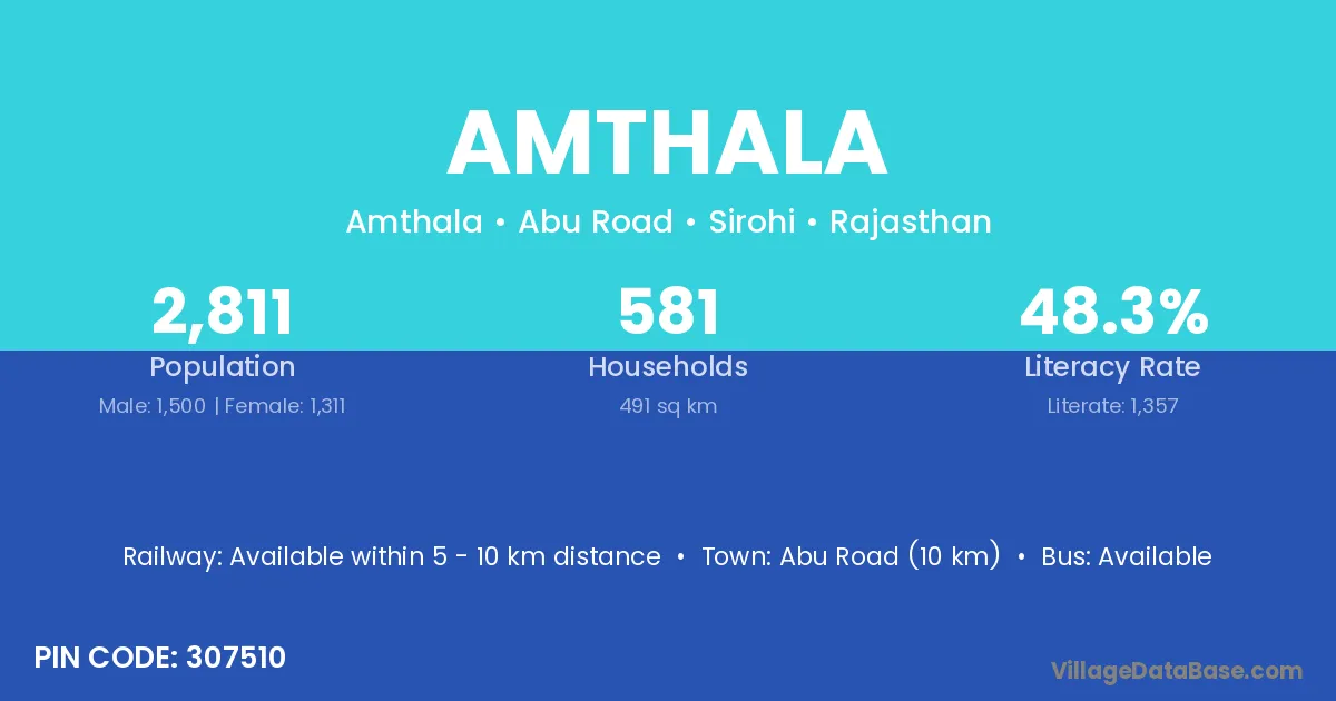
Amthala village is located in the Abu Road Tehsil of the Sirohi district in Rajasthan .

About Amthala Village

Block / Tehsil → Abu Road

District → Sirohi

State → Rajasthan

According to Census 2011 information, the village code of Amthala village is 307510.

Amthala village has a total population of 2,811 people, of which 1,500 are males and 1,311 are females.

The literacy rate of Amthala village is 48.27%. Male literacy stands at 59.07% and female literacy at 35.93%.

There are approximately 581 households in Amthala village.

Abu Road (10 km) is the nearest town to Amthala village for major economic activities and is located approximately 10 km away.

Population of Amthala Village

The population of Amthala village is distributed between literate and illiterate residents as follows:

Population distribution of Amthala village by literacy and gender
Particulars Male Female Total
Literate 886 471 1,357
Illiterate 614 840 1,454
Total 1,500 1,311 2,811

Source: Census 2011

Nearby Villages

List of nearby villages around Amthala village
Village District
Arna Gopalganj
Arna Saran
Arna Saran
Arna Saran
Karoli Gandhinagar
Karoli Gandhinagar
Karoli Kheda
Karoli Panch Mahals
Karoli Sabar Kantha
Karoli Rewari
Karoli Shimla
Karoli Sirmaur
Karoli Solan
Salgaon Hazaribagh
Salgaon Uttara Kannada
Achalgarh Ashoknagar
Karoli Burhanpur
Karoli Dhar
Karoli Khandwa
Karoli Khandwa
Karoli Khargone
Karoli Mandsaur
Karoli Chandrapur
Salgaon Jalna
Salgaon Kolhapur
Karoli Sangli
Karoli Sangli
Salgaon Sindhudurg
Salgaon Thane
Arna Koraput
Karoli Gurdaspur
Karoli Alwar
Karoli Alwar
Kyara Alwar
Karoli Alwar
Karoli Chittaurgarh
Karoli Chittaurgarh
Karoli Churu
Karoli Dausa
Karoli Jaipur
Achalgarh Kota
Karoli Pratapgarh
Karoli Rajsamand
Achalgarh Sirohi
Arna Sirohi
Block No 1 Sirohi
Block No 3 Sirohi
Karoli Sirohi
Kiwarli Sirohi
Kyara Sirohi
Mordu Sirohi
Mudrala Sirohi
Pandoori Sirohi
Salgaon Sirohi
Kyara Udaipur
Kyara Udaipur
Achalgarh Mahrajganj
Kyara Tehri Garhwal

Frequently Asked Questions

Amthala village is located in the Abu Road Tehsil of the Sirohi district in Rajasthan.
The total population is 2,811 people.
1,500 males and 1,311 females.
The literacy rate is 48.27%.
Male literacy rate is 59.07%, and female literacy rate is 35.93%.
There are approximately 581 houses in Amthala village.
Abu Road (10 km) is the nearest town, located approximately 10 km away.

Reviews and Ratings

0.0 / 5 (0 reviews)

Reviews

No reviews yet. Be the first to review this village!

Amthala Village Statistics

Population
2811
Area
491 km²
Households
581
Nearest Town :
Abu Road (10 km)

Quick Information

State / UT : Rajasthan
Pincode : 307510
Total Area : 491 km²
Population : 2811
Households : 581
Gram Panchayat : Amthala
Nearest Town : Abu Road (10 km)

Connectivity of Amthala

🚂 Railway Station

Available within 5 - 10 km distance

🚌 Public Bus Service

Available within village

🚌 Private Bus Service

Available within village

Need Help?

Contact local tourism office for assistance