Welcome Back

Forgot password?
Don't have an account?
🏘️ Menu
Ranchi District 0.0 / 5 (0)

Kathkunwari Village Detailed Information

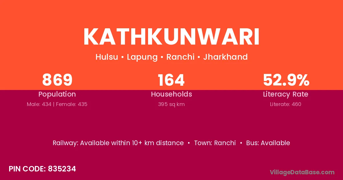
Kathkunwari village is located in the Lapung Subdivision of the Ranchi district in Jharkhand .

About Kathkunwari Village

Block / Subdivision → Lapung

District → Ranchi

State → Jharkhand

According to Census 2011 information, the village code of Kathkunwari village is 835234.

Kathkunwari village has a total population of 869 people, of which 434 are males and 435 are females.

The literacy rate of Kathkunwari village is 52.93%. Male literacy stands at 61.52% and female literacy at 44.37%.

There are approximately 164 households in Kathkunwari village.

Ranchi is the nearest town to Kathkunwari village for major economic activities

Population of Kathkunwari Village

The population of Kathkunwari village is distributed between literate and illiterate residents as follows:

Population distribution of Kathkunwari village by literacy and gender
Particulars Male Female Total
Literate 267 193 460
Illiterate 167 242 409
Total 434 435 869

Source: Census 2011

Nearby Villages

List of nearby villages around Kathkunwari village
Village District
Chanpi Gaya
Chanpi Katihar
Chanpi Purnia
Tapkara Jashpur
Jariya Jashpur
Ulgara Bokaro
Ulgara Bokaro
Jariya Deoghar
Mahugaon Gumla
Mahugaon Gumla
Jariya Gumla
Tapkara Gumla
Chanpi Gumla
Mahugaon Gumla
Chanpi Khunti
Jariya Khunti
Chalangi Khunti
Tangarkela Khunti
Jariya Khunti
Tapkara Khunti
Chanpi Latehar
Ulgara Latehar
Chanpi Lohardaga
Mahugaon Lohardaga
Mahugaon Lohardaga
Chanpi Palamu
Ulgara Palamu
Chanpi Palamu
Chanpi Purbi Singhbhum
Jariya Ranchi
Mahugaon Ranchi
Burhni Ranchi
Chalangi Ranchi
Chanpi Ranchi
Hulsu Ranchi
Jamakel Ranchi
Jariya Ranchi
Kalje Ranchi
Mahugaon Ranchi
Tangarkela Ranchi
Tapkara Ranchi
Ulgara Ranchi
Mahugaon Khargone
Mahugaon Rewa
Jariya Shivpuri
Jariya Banda
Jariya Hamirpur
Jariya Lalitpur
Jariya Rae Bareli
Chanpi Purba Medinipur

Frequently Asked Questions

Kathkunwari village is located in the Lapung Subdivision of the Ranchi district in Jharkhand.
The total population is 869 people.
434 males and 435 females.
The literacy rate is 52.93%.
Male literacy rate is 61.52%, and female literacy rate is 44.37%.
There are approximately 164 houses in Kathkunwari village.
Ranchi is the nearest town, located approximately km away.

Reviews and Ratings

0.0 / 5 (0 reviews)

Reviews

No reviews yet. Be the first to review this village!

Kathkunwari Village Statistics

Population
869
Area
395 km²
Households
164
Nearest Town :
Ranchi

Quick Information

State / UT : Jharkhand
Pincode : 835234
Total Area : 395 km²
Population : 869
Households : 164
Gram Panchayat : Hulsu
Nearest Town : Ranchi

Connectivity of Kathkunwari

🚂 Railway Station

Available within 10+ km distance

🚌 Public Bus Service

Available within 10+ km distance

🚌 Private Bus Service

Available within 5 - 10 km distance

Need Help?

Contact local tourism office for assistance