Welcome Back

Forgot password?
Don't have an account?
🏘️ Menu
Birbhum District 0.0 / 5 (0)

Bara Gare Village Detailed Information

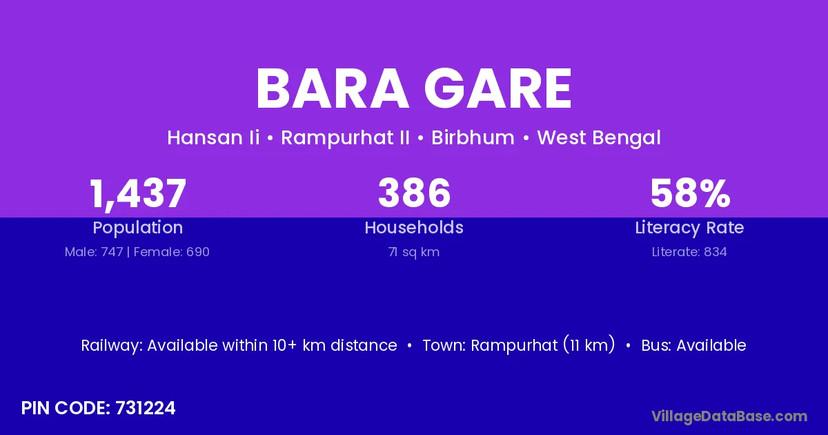
Bara Gare village is located in the Rampurhat II Subdivision of the Birbhum district in West Bengal .

About Bara Gare Village

Block / Subdivision → Rampurhat II

District → Birbhum

State → West Bengal

According to Census 2011 information, the village code of Bara Gare village is 731224.

Bara Gare village has a total population of 1,437 people, of which 747 are males and 690 are females.

The literacy rate of Bara Gare village is 58.04%. Male literacy stands at 61.98% and female literacy at 53.77%.

There are approximately 386 households in Bara Gare village.

Rampurhat (11 km) is the nearest town to Bara Gare village for major economic activities and is located approximately 11 km away.

Population of Bara Gare Village

The population of Bara Gare village is distributed between literate and illiterate residents as follows:

Population distribution of Bara Gare village by literacy and gender
Particulars Male Female Total
Literate 463 371 834
Illiterate 284 319 603
Total 747 690 1,437

Source: Census 2011

Nearby Villages

List of nearby villages around Bara Gare village
Village District
Santoshpur Dhubri
Chandpara Katihar
Malpara Bhavnagar
Malpara Bhavnagar
Malpara Bhavnagar
Malpara Bhavnagar
Chandpara Pakur
Santoshpur Saraikela Kharsawan
Santoshpur Morena
Santoshpur Vidisha
Santoshpur Akola
Malpara Balangir
Malpara Balangir
Malpara Balangir
Malpara Balangir
Malpara Balangir
Santoshpur Baleshwar
Santoshpur Gajapati
Santoshpur Ganjam
Santoshpur Ganjam
Malpara Nabarangapur
Santoshpur Nabarangapur
Santoshpur Sundargarh
Santoshpur Baghpat
Chandpara Bahraich
Santoshpur Bara Banki
Santoshpur Bareilly
Santoshpur Farrukhabad
Santoshpur Jaunpur
Santoshpur Pilibhit
Santoshpur Shahjahanpur
Santoshpur Nainital
Santoshpur Udham Singh Nagar
Malpara Bankura
Chandpara Bankura
Chandpara Bankura
Santoshpur Barddhaman
Shrikrishnapur Barddhaman
Santoshpur Barddhaman
Santoshpur Birbhum
Santoshpur Birbhum
Santoshpur Birbhum
Santoshpur Birbhum
Baje Bujung Birbhum
Bara Karttik Chungri Birbhum
Chandpara Birbhum
Chhota Karttik Chungri Birbhum
Dunigram Birbhum
Hansan Birbhum
Joghar Birbhum
Malpara Birbhum
Pabaipara Birbhum
Santoshpur Birbhum
Shrikrishnapur Birbhum
Santoshpur Haora
Santoshpur Haora
Santoshpur Hugli
Santoshpur Hugli
Santoshpur Hugli
Santoshpur Koch Bihar
Santoshpur Maldah
Santoshpur Murshidabad
Dunigram Murshidabad
Santoshpur Murshidabad
Chandpara Murshidabad
Santoshpur Murshidabad
Malpara Nadia
Santoshpur Nadia
Santoshpur Nadia
Santoshpur North Twenty Four Parganas
Chandpara North Twenty Four Parganas
Malpara Paschim Medinipur
Santoshpur Paschim Medinipur
Shrikrishnapur Paschim Medinipur
Malpara Paschim Medinipur
Shrikrishnapur Purba Medinipur
Santoshpur South Twenty Four Parganas

Frequently Asked Questions

Bara Gare village is located in the Rampurhat II Subdivision of the Birbhum district in West Bengal.
The total population is 1,437 people.
747 males and 690 females.
The literacy rate is 58.04%.
Male literacy rate is 61.98%, and female literacy rate is 53.77%.
There are approximately 386 houses in Bara Gare village.
Rampurhat (11 km) is the nearest town, located approximately 11 km away.

Reviews and Ratings

0.0 / 5 (0 reviews)

Reviews

No reviews yet. Be the first to review this village!

Bara Gare Village Statistics

Population
1437
Area
71 km²
Households
386
Nearest Town :
Rampurhat (11 km)

Quick Information

State / UT : West Bengal
Pincode : 731224
Total Area : 71 km²
Population : 1437
Households : 386
Gram Panchayat : Hansan Ii
Nearest Town : Rampurhat (11 km)

Connectivity of Bara Gare

🚂 Railway Station

Available within 10+ km distance

🚌 Public Bus Service

Available within <5 km distance

🚌 Private Bus Service

Available within <5 km distance

Need Help?

Contact local tourism office for assistance