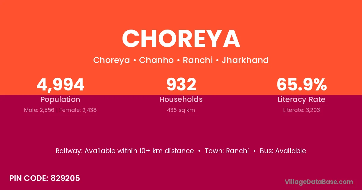
Choreya village is located in the Chanho Subdivision of the Ranchi district in Jharkhand .
Block / Subdivision → Chanho
District → Ranchi
State → Jharkhand
According to Census 2011 information, the village code of Choreya village is 829205.
Choreya village has a total population of 4,994 people, of which 2,556 are males and 2,438 are females.
The literacy rate of Choreya village is 65.94%. Male literacy stands at 73.59% and female literacy at 57.92%.
There are approximately 932 households in Choreya village.
Ranchi is the nearest town to Choreya village for major economic activities
The population of Choreya village is distributed between literate and illiterate residents as follows:
| Particulars | Male | Female | Total |
|---|---|---|---|
| Literate | 1,881 | 1,412 | 3,293 |
| Illiterate | 675 | 1,026 | 1,701 |
| Total | 2,556 | 2,438 | 4,994 |
Source: Census 2011
| Village | District |
|---|---|
| Gutua | Gumla |
| Gutua | Gumla |
| Gutua | Ranchi |
| Harra | Ambala |
| Harra | Godda |
| Harra | Gumla |
| Harra | Ranchi |
| Harra | Anuppur |
| Harra | Betul |
| Harra | Sagar |
| Harra | Shahdol |
| Harra | Sonbhadra |
| Harra | Uttar Dinajpur |
| Harra | Uttar Dinajpur |
| Karkat | Latehar |
| Karkat | Ranchi |
| Karkat | Shahdol |
| Lepsar | Ranchi |
| Lepsar | Ranchi |
| Madhukam | Ranchi |
| Mahthatoli | Ranchi |
| Nunhu | Ranchi |
| Rol | Kabeerdham |
| Rol | Chatra |
| Rol | Hazaribagh |
| Rol | Latehar |
| Rol | Latehar |
| Rol | Palamu |
| Rol | Ranchi |
| Rol | Ranchi |
| Rol | Balaghat |
| Rol | Nagaur |
| Rol | Bankura |
| Sonchipi | Ranchi |
| Soparam | Chatra |
| Soparam | Latehar |
| Soparam | Ranchi |
| Tangar | Raigarh |
| Tangar | Hamirpur |
| Tangar | Pashchimi Singhbhum |
| Tangar | Ranchi |
| Tangar | Ratnagiri |
| Tangar | Kendujhar |
No reviews yet. Be the first to review this village!
Available within 10+ km distance
Available within village
Available within 10+ km distance