Welcome Back

Forgot password?
Don't have an account?
🏘️ Menu
Raigarh District 0.0 / 5 (0)

Kolmandale Village Detailed Information

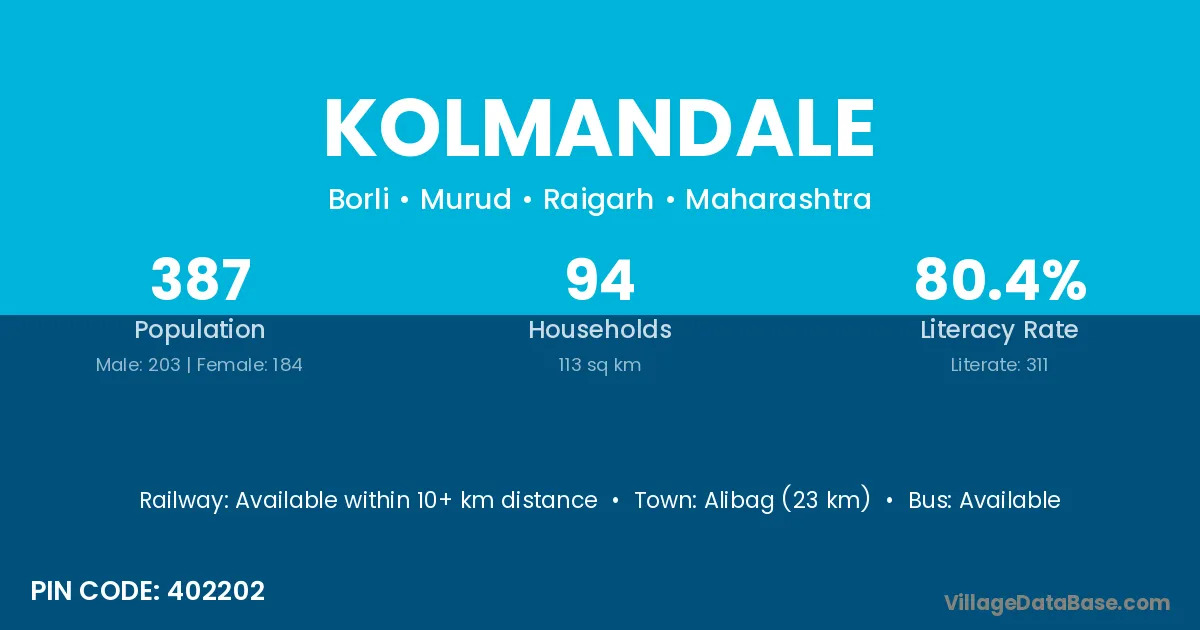
Kolmandale village is located in the Murud Tehsil of the Raigarh district in Maharashtra .

About Kolmandale Village

Block / Tehsil → Murud

District → Raigarh

State → Maharashtra

According to Census 2011 information, the village code of Kolmandale village is 402202.

Kolmandale village has a total population of 387 people, of which 203 are males and 184 are females.

The literacy rate of Kolmandale village is 80.36%. Male literacy stands at 83.74% and female literacy at 76.63%.

There are approximately 94 households in Kolmandale village.

Alibag (23 km) is the nearest town to Kolmandale village for major economic activities and is located approximately 23 km away.

Population of Kolmandale Village

The population of Kolmandale village is distributed between literate and illiterate residents as follows:

Population distribution of Kolmandale village by literacy and gender
Particulars Male Female Total
Literate 170 141 311
Illiterate 33 43 76
Total 203 184 387

Source: Census 2011

Nearby Villages

List of nearby villages around Kolmandale village
Village District
Abitghar Raigarh
Abitghar Thane
Barashiv Raigarh
Borli Sirmaur
Borli Barwani
Borli Barwani
Borli Dhar
Borli Nashik
Borli Raigarh
Borli Barmer
Borli Jalor
Borli Udaipur
Cheher Raigarh
Kakalghar Raigarh
Mahalunge Bk Raigarh
Mahalunge Kh Raigarh
Mandala Banas Kantha
Mandala Narmada
Mandala Vadodara
Mandala Akola
Mandala Jalna
Mandala Nagpur
Mandala Nanded
Mandala Raigarh
Mandala Balangir
Mandala Jalandhar
Mandala Aligarh
Mandala Saharanpur
Mandala Birbhum
Mandala Hugli
Mandala Purba Medinipur
Surai Surendranagar
Surai Chamba
Surai Chhatarpur
Surai Damoh
Surai Jabalpur
Surai Raisen
Surai Raigarh
Surai Raigarh
Surai Raigarh
Surai Thane
Surai Azamgarh
Surai Azamgarh
Surai Garhwal
Talavli Raigarh
Tembhode Raigarh

Frequently Asked Questions

Kolmandale village is located in the Murud Tehsil of the Raigarh district in Maharashtra.
The total population is 387 people.
203 males and 184 females.
The literacy rate is 80.36%.
Male literacy rate is 83.74%, and female literacy rate is 76.63%.
There are approximately 94 houses in Kolmandale village.
Alibag (23 km) is the nearest town, located approximately 23 km away.

Reviews and Ratings

0.0 / 5 (0 reviews)

Reviews

No reviews yet. Be the first to review this village!

Kolmandale Village Statistics

Population
387
Area
113 km²
Households
94
Nearest Town :
Alibag (23 km)

Quick Information

State / UT : Maharashtra
Pincode : 402202
Total Area : 113 km²
Population : 387
Households : 94
Gram Panchayat : Borli
Nearest Town : Alibag (23 km)

Connectivity of Kolmandale

🚂 Railway Station

Available within 10+ km distance

🚌 Public Bus Service

Available within <5 km distance

🚌 Private Bus Service

Available within 10+ km distance

Need Help?

Contact local tourism office for assistance