Welcome Back

Forgot password?
Don't have an account?
🏘️ Menu
Murshidabad District 0.0 / 5 (0)

Garsama Village Detailed Information

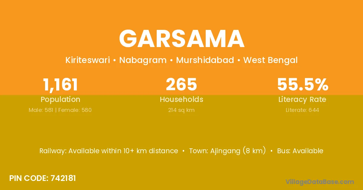
Garsama village is located in the Nabagram Subdivision of the Murshidabad district in West Bengal .

About Garsama Village

Block / Subdivision → Nabagram

District → Murshidabad

State → West Bengal

According to Census 2011 information, the village code of Garsama village is 742181.

Garsama village has a total population of 1,161 people, of which 581 are males and 580 are females.

The literacy rate of Garsama village is 55.47%. Male literacy stands at 61.10% and female literacy at 49.83%.

There are approximately 265 households in Garsama village.

Ajingang (8 km) is the nearest town to Garsama village for major economic activities and is located approximately 8 km away.

Population of Garsama Village

The population of Garsama village is distributed between literate and illiterate residents as follows:

Population distribution of Garsama village by literacy and gender
Particulars Male Female Total
Literate 355 289 644
Illiterate 226 291 517
Total 581 580 1,161

Source: Census 2011

Nearby Villages

List of nearby villages around Garsama village
Village District
Bundai Danga Murshidabad
Damrul Murshidabad
Damrul Murshidabad
Itor Murshidabad
Itor Murshidabad
Itor Murshidabad
Itor Murshidabad
Kethor Murshidabad
Kethor Murshidabad
Khajuria Begusarai
Khajuria Bhagalpur
Khajuria Bhagalpur
Khajuria Bhojpur
Khajuria Gopalganj
Khajuria Gopalganj
Khajuria Kaimur
Khajuria Katihar
Khajuria Munger
Khajuria Pashchim Champaran
Khajuria Palamu
Khajuria Palamu
Khajuria Pashchimi Singhbhum
Khajuria Sahibganj
Khajuria Dhar
Khajuria Neemuch
Khajuria Rajgarh
Khajuria Sagar
Khajuria Sagar
Khajuria Ujjain
Khajuria Anugul
Khajuria Anugul
Khajuria Anugul
Khajuria Bargarh
Khajuria Baudh
Khajuria Cuttack
Khajuria Dhenkanal
Khajuria Dhenkanal
Khajuria Ganjam
Khajuria Ganjam
Khajuria Ganjam
Khajuria Ganjam
Khajuria Jajapur
Khajuria Kendujhar
Khajuria Khordha
Khajuria Khordha
Khajuria Nayagarh
Khajuria Azamgarh
Khajuria Balrampur
Khajuria Bara Banki
Khajuria Bareilly
Khajuria Bareilly
Khajuria Basti
Khajuria Budaun
Khajuria Deoria
Khajuria Gorakhpur
Khajuria Kanshiram Nagar
Khajuria Kheri
Khajuria Kushinagar
Khajuria Mahamaya Nagar
Khajuria Mahrajganj
Khajuria Mahrajganj
Khajuria Mahrajganj
Khajuria Pilibhit
Khajuria Sant Kabir Nagar
Khajuria Shahjahanpur
Khajuria Siddharthnagar
Khajuria Birbhum
Khajuria Murshidabad
Kiriteswri Murshidabad
Kongarpur Murshidabad
Mathurapur Cachar
Mathurapur Nalbari
Mathurapur Aurangabad
Mathurapur Banka
Mathurapur Begusarai
Mathurapur Bhagalpur
Mathurapur Bhojpur
Mathurapur Bhojpur
Mathurapur Bhojpur
Mathurapur Bhojpur
Mathurapur Darbhanga
Mathurapur Gaya
Mathurapur Gopalganj
Mathurapur Jamui
Mathurapur Katihar
Mathurapur Katihar
Mathurapur Katihar
Mathurapur Khagaria
Mathurapur Muzaffarpur
Mathurapur Purba Champaran
Mathurapur Rohtas
Mathurapur Rohtas
Mathurapur Rohtas
Mathurapur Samastipur
Mathurapur Saran
Mathurapur Siwan
Mathurapur Vaishali
Mathurapur Chatra
Mathurapur Deoghar
Mathurapur Deoghar
Mathurapur Purbi Singhbhum
Mathurapur Cuttack
Mathurapur Cuttack
Mathurapur Jajapur
Mathurapur Kendujhar
Mathurapur Ambedkar Nagar
Mathurapur Azamgarh
Mathurapur Azamgarh
Mathurapur Bareilly
Mathurapur Basti
Mathurapur Fatehpur
Mathurapur Gautam Buddha Nagar
Mathurapur Ghaziabad
Mathurapur Jaunpur
Mathurapur Mahamaya Nagar
Mathurapur Rampur
Mathurapur Sant Kabir Nagar
Mathurapur Sant Ravidas Nagar
Mathurapur Shahjahanpur
Mathurapur Siddharthnagar
Mathurapur Barddhaman
Mathurapur Birbhum
Mathurapur Dakshin Dinajpur
Mathurapur Maldah
Mathurapur Maldah
Mathurapur Maldah
Mathurapur Murshidabad
Mathurapur Nadia
Mathurapur Nadia
Mathurapur Nadia
Mathurapur Nadia
Mathurapur North Twenty Four Parganas
Mathurapur Paschim Medinipur
Mathurapur Purba Medinipur
Mathurapur South Twenty Four Parganas
Mathurapur Uttar Dinajpur
Mathurapur Maldah
Mathurapur Maldah
Mathurapur Maldah
Mathurapur Murshidabad
Mathurapur Nadia
Mathurapur Nadia
Mathurapur Nadia
Mathurapur Nadia
Mathurapur North Twenty Four Parganas
Mathurapur Paschim Medinipur
Mathurapur Purba Medinipur
Mathurapur South Twenty Four Parganas
Mathurapur Uttar Dinajpur
Nagara Vizianagaram
Nagara Bhagalpur
Nagara Surendranagar
Nagara Shivpuri
Nagara Tikamgarh
Nagara Gondiya
Nagara Faizabad
Nagara Gorakhpur
Nagara Hardoi
Nagara Jhansi
Nagara Lalitpur
Nagara Siddharthnagar
Nagara Murshidabad
Nagara Murshidabad
Sibrambati Dakshin Dinajpur
Sibrambati Murshidabad
Tiadanga Murshidabad

Frequently Asked Questions

Garsama village is located in the Nabagram Subdivision of the Murshidabad district in West Bengal.
The total population is 1,161 people.
581 males and 580 females.
The literacy rate is 55.47%.
Male literacy rate is 61.10%, and female literacy rate is 49.83%.
There are approximately 265 houses in Garsama village.
Ajingang (8 km) is the nearest town, located approximately 8 km away.

Reviews and Ratings

0.0 / 5 (0 reviews)

Reviews

No reviews yet. Be the first to review this village!

Garsama Village Statistics

Population
1161
Area
214 km²
Households
265
Nearest Town :
Ajingang (8 km)

Quick Information

State / UT : West Bengal
Pincode : 742181
Total Area : 214 km²
Population : 1161
Households : 265
Gram Panchayat : Kiriteswari
Nearest Town : Ajingang (8 km)

Connectivity of Garsama

🚂 Railway Station

Available within 10+ km distance

🚌 Public Bus Service

Available within 5 - 10 km distance

🚌 Private Bus Service

Available within 5 - 10 km distance

Need Help?

Contact local tourism office for assistance